You are here: Home > Network List > TA - USArray Transportable Network (new EarthScope stations) Stations List
> Station G13A Cobalt, ID, USA > Earthquake Result Viewer
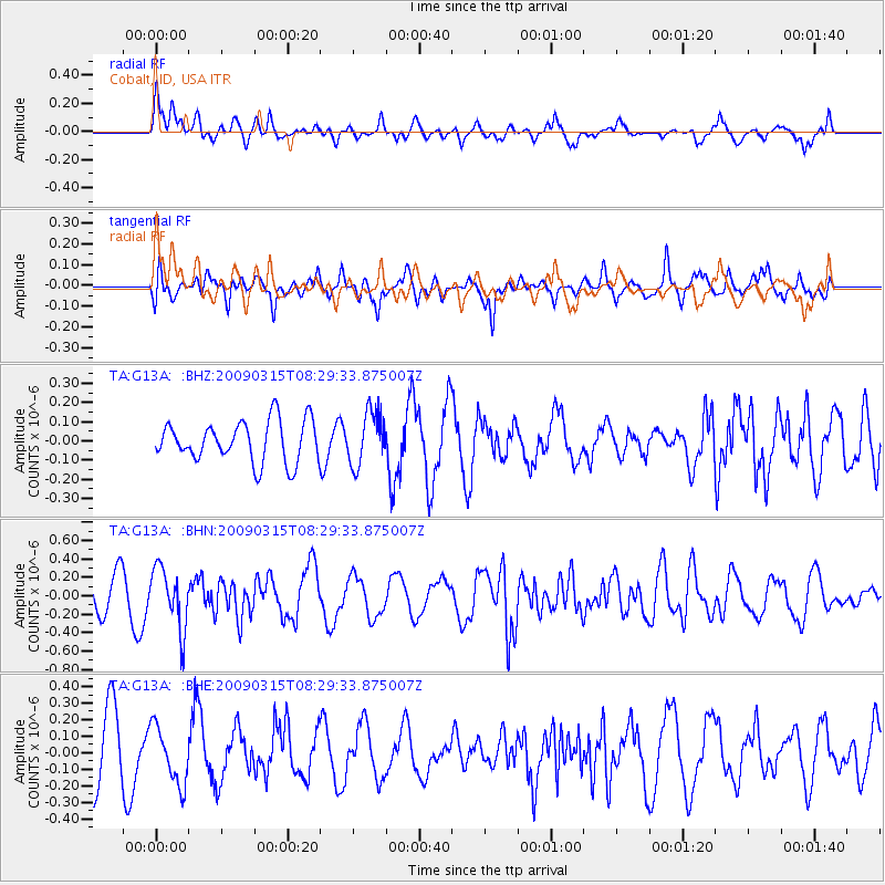
G13A Cobalt, ID, USA - Earthquake Result Viewer
*The percent match for this event was below the threshold and hence no stack was calculated.
| Earthquake location: |
Central Peru |
| Earthquake latitude/longitude: |
-14.5/-70.4 |
| Earthquake time(UTC): |
2009/03/15 (074) 08:19:05 GMT |
| Earthquake Depth: |
190 km |
| Earthquake Magnitude: |
5.7 MW, 5.1 MB, 5.6 MW |
| Earthquake Catalog/Contributor: |
WHDF/NEIC |
|
| Network: |
TA USArray Transportable Network (new EarthScope stations) |
| Station: |
G13A Cobalt, ID, USA |
| Lat/Lon: |
45.09 N/114.23 W |
| Elevation: |
1538 m |
|
| Distance: |
71.4 deg |
| Az: |
328.798 deg |
| Baz: |
134.885 deg |
| Ray Param: |
$rayparam |
*The percent match for this event was below the threshold and hence was not used in the summary stack. |
|
| Radial Match: |
49.875916 % |
| Radial Bump: |
400 |
| Transverse Match: |
43.02424 % |
| Transverse Bump: |
400 |
| SOD ConfigId: |
2658 |
| Insert Time: |
2010-03-06 05:14:01.916 +0000 |
| GWidth: |
2.5 |
| Max Bumps: |
400 |
| Tol: |
0.001 |
|
Signal To Noise
| Channel | StoN | STA | LTA |
| TA:G13A: :BHN:20090315T08:29:33.875007Z | 2.0390112 | 3.2488316E-7 | 1.5933368E-7 |
| TA:G13A: :BHE:20090315T08:29:33.875007Z | 1.0194851 | 1.750517E-7 | 1.7170599E-7 |
| TA:G13A: :BHZ:20090315T08:29:33.875007Z | 1.3120836 | 1.3937232E-7 | 1.0622213E-7 |
| Arrivals |
| Ps | |
| PpPs | |
| PsPs/PpSs | |


