You are here: Home > Network List > TA - USArray Transportable Network (new EarthScope stations) Stations List
> Station BGNE Belgrade, NE, USA > Earthquake Result Viewer
BGNE Belgrade, NE, USA - Earthquake Result Viewer

| Earthquake location: |
Northern Chile |
| Earthquake latitude/longitude: |
-18.5/-69.6 |
| Earthquake time(UTC): |
2017/10/10 (283) 06:32:20 GMT |
| Earthquake Depth: |
82 km |
| Earthquake Magnitude: |
6.3 Mww |
| Earthquake Catalog/Contributor: |
NEIC PDE/us |
|
| Network: |
TA USArray Transportable Network (new EarthScope stations) |
| Station: |
BGNE Belgrade, NE, USA |
| Lat/Lon: |
41.41 N/98.15 W |
| Elevation: |
573 m |
|
| Distance: |
65.2 deg |
| Az: |
336.706 deg |
| Baz: |
150.079 deg |
| Ray Param: |
0.05820582 |
| Estimated Moho Depth: |
34.25 km |
| Estimated Crust Vp/Vs: |
1.63 |
| Assumed Crust Vp: |
6.53 km/s |
| Estimated Crust Vs: |
4.0 km/s |
| Estimated Crust Poisson's Ratio: |
0.20 |
|
| Radial Match: |
94.22644 % |
| Radial Bump: |
361 |
| Transverse Match: |
86.88834 % |
| Transverse Bump: |
400 |
| SOD ConfigId: |
13570011 |
| Insert Time: |
2019-04-28 23:33:37.551 +0000 |
| GWidth: |
2.5 |
| Max Bumps: |
400 |
| Tol: |
0.001 |
|
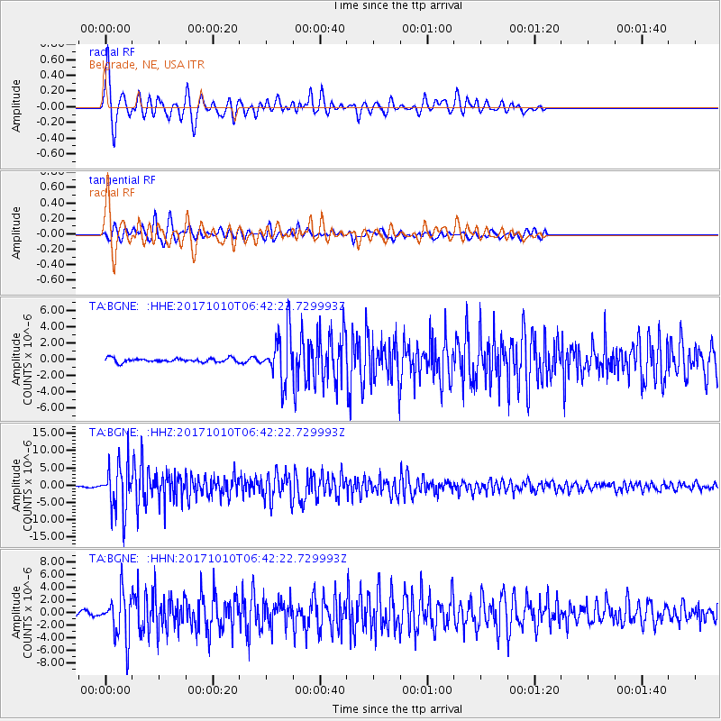
Signal To Noise
| Channel | StoN | STA | LTA |
| TA:BGNE: :HHZ:20171010T06:42:22.729993Z | 42.916916 | 6.8054674E-6 | 1.5857307E-7 |
| TA:BGNE: :HHN:20171010T06:42:22.729993Z | 12.189615 | 3.5918586E-6 | 2.9466548E-7 |
| TA:BGNE: :HHE:20171010T06:42:22.729993Z | 12.603377 | 3.0536078E-6 | 2.4228487E-7 |
| Arrivals |
| Ps | 3.5 SECOND |
| PpPs | 13 SECOND |
| PsPs/PpSs | 17 SECOND |


