You are here: Home > Network List > TA - USArray Transportable Network (new EarthScope stations) Stations List
> Station G13A Cobalt, ID, USA > Earthquake Result Viewer
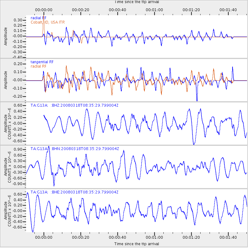
G13A Cobalt, ID, USA - Earthquake Result Viewer
*The percent match for this event was below the threshold and hence no stack was calculated.
| Earthquake location: |
Kermadec Islands, New Zealand |
| Earthquake latitude/longitude: |
-29.3/-177.4 |
| Earthquake time(UTC): |
2008/03/18 (078) 08:22:47 GMT |
| Earthquake Depth: |
25 km |
| Earthquake Magnitude: |
5.8 MB, 6.1 MS, 6.2 MW, 6.2 MW |
| Earthquake Catalog/Contributor: |
WHDF/NEIC |
|
| Network: |
TA USArray Transportable Network (new EarthScope stations) |
| Station: |
G13A Cobalt, ID, USA |
| Lat/Lon: |
45.09 N/114.23 W |
| Elevation: |
1538 m |
|
| Distance: |
93.7 deg |
| Az: |
39.316 deg |
| Baz: |
231.413 deg |
| Ray Param: |
$rayparam |
*The percent match for this event was below the threshold and hence was not used in the summary stack. |
|
| Radial Match: |
55.839462 % |
| Radial Bump: |
400 |
| Transverse Match: |
39.179985 % |
| Transverse Bump: |
335 |
| SOD ConfigId: |
2504 |
| Insert Time: |
2010-03-06 05:14:08.386 +0000 |
| GWidth: |
2.5 |
| Max Bumps: |
400 |
| Tol: |
0.001 |
|
Signal To Noise
| Channel | StoN | STA | LTA |
| TA:G13A: :BHN:20080318T08:35:29.799004Z | 1.86367 | 6.0774863E-7 | 3.2610313E-7 |
| TA:G13A: :BHE:20080318T08:35:29.799004Z | 0.9572756 | 2.6078555E-7 | 2.7242476E-7 |
| TA:G13A: :BHZ:20080318T08:35:29.799004Z | 1.03188 | 2.2123433E-7 | 2.1439926E-7 |
| Arrivals |
| Ps | |
| PpPs | |
| PsPs/PpSs | |


