You are here: Home > Network List > TA - USArray Transportable Network (new EarthScope stations) Stations List
> Station KSCO Kaye Shedlock's, Cheyenne Wells, CO, USA > Earthquake Result Viewer
KSCO Kaye Shedlock's, Cheyenne Wells, CO, USA - Earthquake Result Viewer
| Earthquake location: |
Northern Chile |
| Earthquake latitude/longitude: |
-18.5/-69.6 |
| Earthquake time(UTC): |
2017/10/10 (283) 06:32:20 GMT |
| Earthquake Depth: |
82 km |
| Earthquake Magnitude: |
6.3 Mww |
| Earthquake Catalog/Contributor: |
NEIC PDE/us |
|
| Network: |
TA USArray Transportable Network (new EarthScope stations) |
| Station: |
KSCO Kaye Shedlock's, Cheyenne Wells, CO, USA |
| Lat/Lon: |
39.01 N/102.63 W |
| Elevation: |
1382 m |
|
| Distance: |
65.0 deg |
| Az: |
332.102 deg |
| Baz: |
145.261 deg |
| Ray Param: |
0.05832905 |
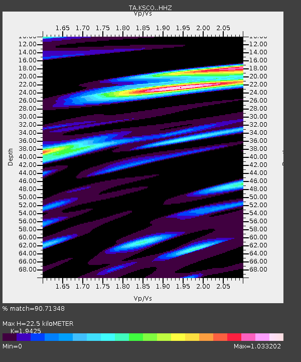
| Estimated Moho Depth: |
22.5 km |
| Estimated Crust Vp/Vs: |
1.94 |
| Assumed Crust Vp: |
6.242 km/s |
| Estimated Crust Vs: |
3.213 km/s |
| Estimated Crust Poisson's Ratio: |
0.32 |
|
| Radial Match: |
90.71348 % |
| Radial Bump: |
382 |
| Transverse Match: |
70.73221 % |
| Transverse Bump: |
359 |
| SOD ConfigId: |
13570011 |
| Insert Time: |
2019-04-28 23:33:41.860 +0000 |
| GWidth: |
2.5 |
| Max Bumps: |
400 |
| Tol: |
0.001 |
|

Signal To Noise
| Channel | StoN | STA | LTA |
| TA:KSCO: :HHZ:20171010T06:42:21.510022Z | 16.39518 | 3.2358444E-6 | 1.9736558E-7 |
| TA:KSCO: :HHN:20171010T06:42:21.510022Z | 4.502891 | 1.033796E-6 | 2.2958496E-7 |
| TA:KSCO: :HHE:20171010T06:42:21.510022Z | 3.2362447 | 1.0084962E-6 | 3.1162543E-7 |
| Arrivals |
| Ps | 3.5 SECOND |
| PpPs | 10 SECOND |
| PsPs/PpSs | 14 SECOND |


