You are here: Home > Network List > TA - USArray Transportable Network (new EarthScope stations) Stations List
> Station M53A WI Miller and Sons, Farmdale, OH, USA > Earthquake Result Viewer
M53A WI Miller and Sons, Farmdale, OH, USA - Earthquake Result Viewer
| Earthquake location: |
Northern Chile |
| Earthquake latitude/longitude: |
-18.5/-69.6 |
| Earthquake time(UTC): |
2017/10/10 (283) 06:32:20 GMT |
| Earthquake Depth: |
82 km |
| Earthquake Magnitude: |
6.3 Mww |
| Earthquake Catalog/Contributor: |
NEIC PDE/us |
|
| Network: |
TA USArray Transportable Network (new EarthScope stations) |
| Station: |
M53A WI Miller and Sons, Farmdale, OH, USA |
| Lat/Lon: |
41.44 N/80.68 W |
| Elevation: |
334 m |
|
| Distance: |
60.5 deg |
| Az: |
350.486 deg |
| Baz: |
167.96 deg |
| Ray Param: |
0.061249506 |
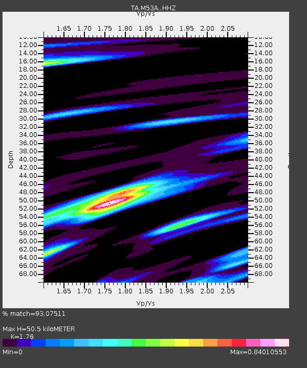
| Estimated Moho Depth: |
50.5 km |
| Estimated Crust Vp/Vs: |
1.76 |
| Assumed Crust Vp: |
6.483 km/s |
| Estimated Crust Vs: |
3.683 km/s |
| Estimated Crust Poisson's Ratio: |
0.26 |
|
| Radial Match: |
93.07511 % |
| Radial Bump: |
346 |
| Transverse Match: |
81.34737 % |
| Transverse Bump: |
400 |
| SOD ConfigId: |
13570011 |
| Insert Time: |
2019-04-28 23:33:44.739 +0000 |
| GWidth: |
2.5 |
| Max Bumps: |
400 |
| Tol: |
0.001 |
|

Signal To Noise
| Channel | StoN | STA | LTA |
| TA:M53A: :HHZ:20171010T06:41:51.659985Z | 28.206196 | 7.793598E-6 | 2.7630801E-7 |
| TA:M53A: :HHN:20171010T06:41:51.659985Z | 13.478347 | 2.6077128E-6 | 1.9347422E-7 |
| TA:M53A: :HHE:20171010T06:41:51.659985Z | 2.9822497 | 6.1755344E-7 | 2.0707637E-7 |
| Arrivals |
| Ps | 6.2 SECOND |
| PpPs | 21 SECOND |
| PsPs/PpSs | 27 SECOND |


