You are here: Home > Network List > TA - USArray Transportable Network (new EarthScope stations) Stations List
> Station G13A Cobalt, ID, USA > Earthquake Result Viewer
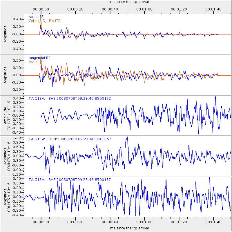
G13A Cobalt, ID, USA - Earthquake Result Viewer
*The percent match for this event was below the threshold and hence no stack was calculated.
| Earthquake location: |
Southern Peru |
| Earthquake latitude/longitude: |
-16.0/-71.7 |
| Earthquake time(UTC): |
2008/07/08 (190) 09:13:07 GMT |
| Earthquake Depth: |
123 km |
| Earthquake Magnitude: |
5.8 MB, 6.2 MW, 6.2 MW |
| Earthquake Catalog/Contributor: |
WHDF/NEIC |
|
| Network: |
TA USArray Transportable Network (new EarthScope stations) |
| Station: |
G13A Cobalt, ID, USA |
| Lat/Lon: |
45.09 N/114.23 W |
| Elevation: |
1538 m |
|
| Distance: |
72.0 deg |
| Az: |
329.797 deg |
| Baz: |
136.915 deg |
| Ray Param: |
$rayparam |
*The percent match for this event was below the threshold and hence was not used in the summary stack. |
|
| Radial Match: |
82.305115 % |
| Radial Bump: |
400 |
| Transverse Match: |
70.272934 % |
| Transverse Bump: |
400 |
| SOD ConfigId: |
2504 |
| Insert Time: |
2010-03-06 05:14:31.432 +0000 |
| GWidth: |
2.5 |
| Max Bumps: |
400 |
| Tol: |
0.001 |
|
Signal To Noise
| Channel | StoN | STA | LTA |
| TA:G13A: :BHN:20080708T09:23:46.850015Z | 4.6298547 | 3.7111002E-7 | 8.0155864E-8 |
| TA:G13A: :BHE:20080708T09:23:46.850015Z | 1.7187241 | 8.0284636E-8 | 4.671176E-8 |
| TA:G13A: :BHZ:20080708T09:23:46.850015Z | 0.83775115 | 6.972846E-8 | 8.32329E-8 |
| Arrivals |
| Ps | |
| PpPs | |
| PsPs/PpSs | |


