You are here: Home > Network List > TA - USArray Transportable Network (new EarthScope stations) Stations List
> Station G13A Cobalt, ID, USA > Earthquake Result Viewer
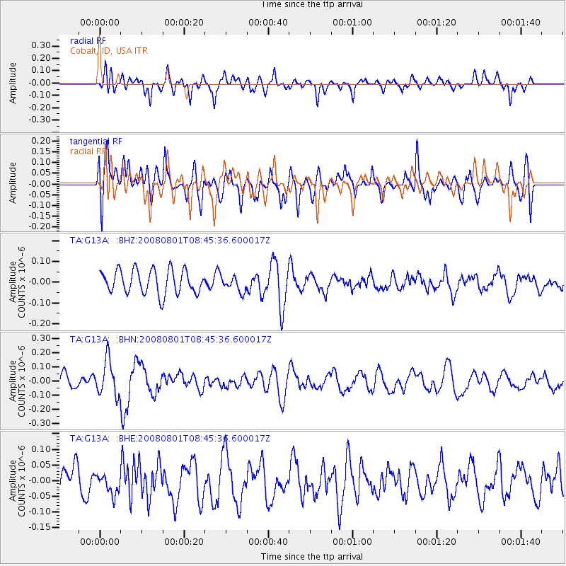
G13A Cobalt, ID, USA - Earthquake Result Viewer
*The percent match for this event was below the threshold and hence no stack was calculated.
| Earthquake location: |
Sichuan, China |
| Earthquake latitude/longitude: |
32.0/104.7 |
| Earthquake time(UTC): |
2008/08/01 (214) 08:32:43 GMT |
| Earthquake Depth: |
7.0 km |
| Earthquake Magnitude: |
5.9 MB, 5.6 MS, 5.7 MW, 5.7 MW |
| Earthquake Catalog/Contributor: |
WHDF/NEIC |
|
| Network: |
TA USArray Transportable Network (new EarthScope stations) |
| Station: |
G13A Cobalt, ID, USA |
| Lat/Lon: |
45.09 N/114.23 W |
| Elevation: |
1538 m |
|
| Distance: |
95.5 deg |
| Az: |
26.575 deg |
| Baz: |
327.561 deg |
| Ray Param: |
$rayparam |
*The percent match for this event was below the threshold and hence was not used in the summary stack. |
|
| Radial Match: |
62.46713 % |
| Radial Bump: |
400 |
| Transverse Match: |
54.685997 % |
| Transverse Bump: |
400 |
| SOD ConfigId: |
2504 |
| Insert Time: |
2010-03-06 05:14:34.417 +0000 |
| GWidth: |
2.5 |
| Max Bumps: |
400 |
| Tol: |
0.001 |
|
Signal To Noise
| Channel | StoN | STA | LTA |
| TA:G13A: :BHN:20080801T08:45:36.600017Z | 1.7686132 | 1.2813761E-7 | 7.2450895E-8 |
| TA:G13A: :BHE:20080801T08:45:36.600017Z | 0.8797132 | 3.5676408E-8 | 4.055459E-8 |
| TA:G13A: :BHZ:20080801T08:45:36.600017Z | 0.653375 | 3.721234E-8 | 5.6954033E-8 |
| Arrivals |
| Ps | |
| PpPs | |
| PsPs/PpSs | |


