You are here: Home > Network List > TA - USArray Transportable Network (new EarthScope stations) Stations List
> Station H12A Diamond D Ranch, Stanley, ID, USA > Earthquake Result Viewer
H12A Diamond D Ranch, Stanley, ID, USA - Earthquake Result Viewer
| Earthquake location: |
Solomon Islands |
| Earthquake latitude/longitude: |
-9.8/159.5 |
| Earthquake time(UTC): |
2007/08/16 (228) 08:39:27 GMT |
| Earthquake Depth: |
10 km |
| Earthquake Magnitude: |
6.1 MB, 6.7 MS, 6.4 MW |
| Earthquake Catalog/Contributor: |
WHDF/NEIC |
|
| Network: |
TA USArray Transportable Network (new EarthScope stations) |
| Station: |
H12A Diamond D Ranch, Stanley, ID, USA |
| Lat/Lon: |
44.55 N/114.86 W |
| Elevation: |
1777 m |
|
| Distance: |
93.8 deg |
| Az: |
45.602 deg |
| Baz: |
260.004 deg |
| Ray Param: |
0.041198205 |
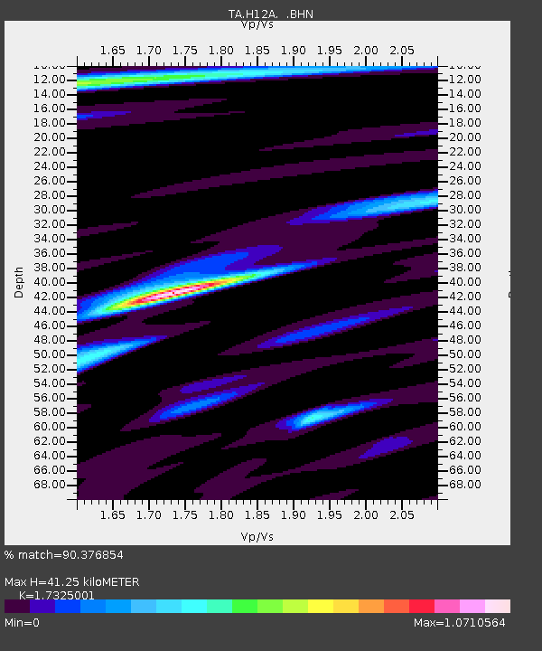
| Estimated Moho Depth: |
41.25 km |
| Estimated Crust Vp/Vs: |
1.73 |
| Assumed Crust Vp: |
6.577 km/s |
| Estimated Crust Vs: |
3.796 km/s |
| Estimated Crust Poisson's Ratio: |
0.25 |
|
| Radial Match: |
90.376854 % |
| Radial Bump: |
400 |
| Transverse Match: |
83.96787 % |
| Transverse Bump: |
400 |
| SOD ConfigId: |
2564 |
| Insert Time: |
2010-03-06 05:15:25.745 +0000 |
| GWidth: |
2.5 |
| Max Bumps: |
400 |
| Tol: |
0.001 |
|
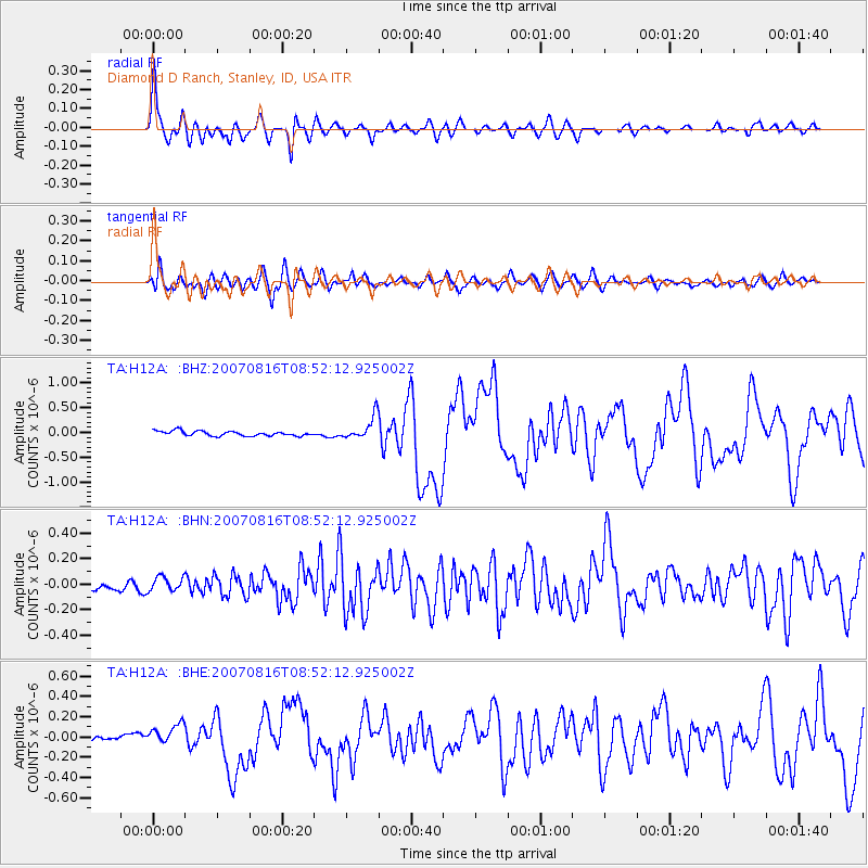
Signal To Noise
| Channel | StoN | STA | LTA |
| TA:H12A: :BHN:20070816T08:52:12.925002Z | 1.6096746 | 5.4456688E-8 | 3.383087E-8 |
| TA:H12A: :BHE:20070816T08:52:12.925002Z | 3.4011495 | 1.18812856E-7 | 3.4933148E-8 |
| TA:H12A: :BHZ:20070816T08:52:12.925002Z | 4.765742 | 2.3112314E-7 | 4.8496783E-8 |
| Arrivals |
| Ps | 4.7 SECOND |
| PpPs | 17 SECOND |
| PsPs/PpSs | 21 SECOND |


