You are here: Home > Network List > TA - USArray Transportable Network (new EarthScope stations) Stations List
> Station H12A Diamond D Ranch, Stanley, ID, USA > Earthquake Result Viewer
H12A Diamond D Ranch, Stanley, ID, USA - Earthquake Result Viewer
| Earthquake location: |
Jujuy Province, Argentina |
| Earthquake latitude/longitude: |
-22.2/-65.8 |
| Earthquake time(UTC): |
2007/07/21 (202) 15:34:52 GMT |
| Earthquake Depth: |
290 km |
| Earthquake Magnitude: |
5.8 MB, 6.4 MW, 6.3 MW |
| Earthquake Catalog/Contributor: |
WHDF/NEIC |
|
| Network: |
TA USArray Transportable Network (new EarthScope stations) |
| Station: |
H12A Diamond D Ranch, Stanley, ID, USA |
| Lat/Lon: |
44.55 N/114.86 W |
| Elevation: |
1777 m |
|
| Distance: |
80.1 deg |
| Az: |
326.74 deg |
| Baz: |
134.674 deg |
| Ray Param: |
0.047757242 |
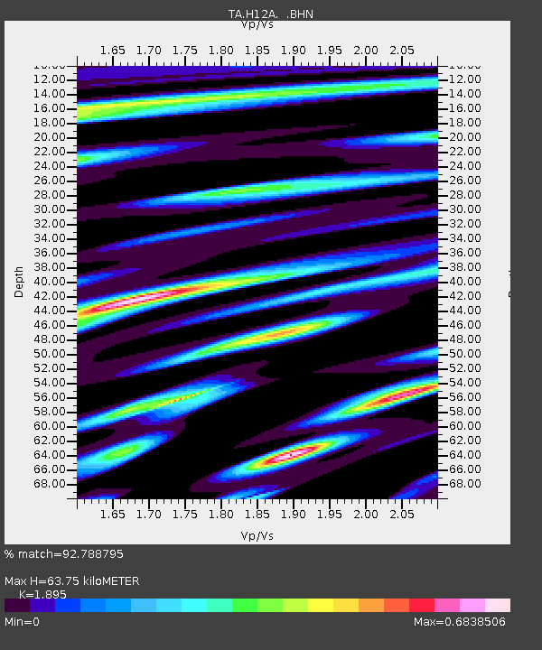
| Estimated Moho Depth: |
63.75 km |
| Estimated Crust Vp/Vs: |
1.89 |
| Assumed Crust Vp: |
6.577 km/s |
| Estimated Crust Vs: |
3.471 km/s |
| Estimated Crust Poisson's Ratio: |
0.31 |
|
| Radial Match: |
92.788795 % |
| Radial Bump: |
400 |
| Transverse Match: |
75.3344 % |
| Transverse Bump: |
400 |
| SOD ConfigId: |
2564 |
| Insert Time: |
2010-03-06 05:15:35.841 +0000 |
| GWidth: |
2.5 |
| Max Bumps: |
400 |
| Tol: |
0.001 |
|
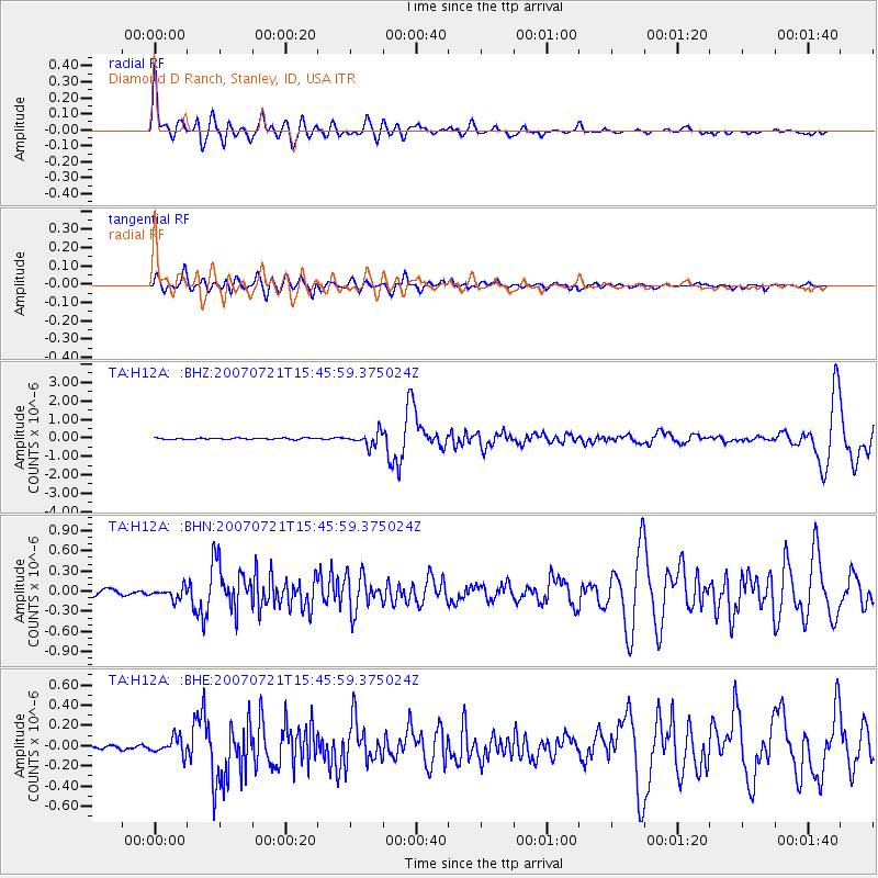
Signal To Noise
| Channel | StoN | STA | LTA |
| TA:H12A: :BHN:20070721T15:45:59.375024Z | 1.7234408 | 8.218536E-8 | 4.768679E-8 |
| TA:H12A: :BHE:20070721T15:45:59.375024Z | 2.4472933 | 8.29126E-8 | 3.3879306E-8 |
| TA:H12A: :BHZ:20070721T15:45:59.375024Z | 10.390882 | 3.6320017E-7 | 3.495374E-8 |
| Arrivals |
| Ps | 8.9 SECOND |
| PpPs | 27 SECOND |
| PsPs/PpSs | 36 SECOND |


