You are here: Home > Network List > CI - Caltech Regional Seismic Network Stations List
> Station SWS Sam W. Stewart, Westmorland, CA, USA > Earthquake Result Viewer
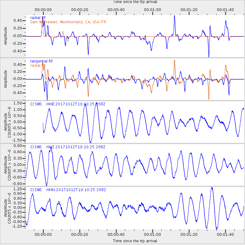
SWS Sam W. Stewart, Westmorland, CA, USA - Earthquake Result Viewer
*The percent match for this event was below the threshold and hence no stack was calculated.
| Earthquake location: |
Cordoba Province, Argentina |
| Earthquake latitude/longitude: |
-31.0/-65.6 |
| Earthquake time(UTC): |
2017/10/12 (285) 18:59:08 GMT |
| Earthquake Depth: |
157 km |
| Earthquake Magnitude: |
5.5 Mww |
| Earthquake Catalog/Contributor: |
NEIC PDE/us |
|
| Network: |
CI Caltech Regional Seismic Network |
| Station: |
SWS Sam W. Stewart, Westmorland, CA, USA |
| Lat/Lon: |
32.94 N/115.80 W |
| Elevation: |
140 m |
|
| Distance: |
79.4 deg |
| Az: |
318.888 deg |
| Baz: |
137.825 deg |
| Ray Param: |
$rayparam |
*The percent match for this event was below the threshold and hence was not used in the summary stack. |
|
| Radial Match: |
56.60536 % |
| Radial Bump: |
332 |
| Transverse Match: |
58.75342 % |
| Transverse Bump: |
271 |
| SOD ConfigId: |
13570011 |
| Insert Time: |
2019-04-28 23:42:10.069 +0000 |
| GWidth: |
2.5 |
| Max Bumps: |
400 |
| Tol: |
0.001 |
|
Signal To Noise
| Channel | StoN | STA | LTA |
| CI:SWS: :HHZ:20171012T19:10:25.268Z | 1.5807303 | 6.4588045E-7 | 4.0859624E-7 |
| CI:SWS: :HHN:20171012T19:10:25.268Z | 0.5811687 | 2.8612968E-7 | 4.9233495E-7 |
| CI:SWS: :HHE:20171012T19:10:25.268Z | 1.4278013 | 9.323383E-7 | 6.5298883E-7 |
| Arrivals |
| Ps | |
| PpPs | |
| PsPs/PpSs | |


