You are here: Home > Network List > TA - USArray Transportable Network (new EarthScope stations) Stations List
> Station H12A Diamond D Ranch, Stanley, ID, USA > Earthquake Result Viewer
H12A Diamond D Ranch, Stanley, ID, USA - Earthquake Result Viewer
| Earthquake location: |
Kamchatka Peninsula, Russia |
| Earthquake latitude/longitude: |
52.1/157.3 |
| Earthquake time(UTC): |
2007/05/30 (150) 20:22:12 GMT |
| Earthquake Depth: |
116 km |
| Earthquake Magnitude: |
6.4 MB, 6.4 MW, 6.4 MW |
| Earthquake Catalog/Contributor: |
WHDF/NEIC |
|
| Network: |
TA USArray Transportable Network (new EarthScope stations) |
| Station: |
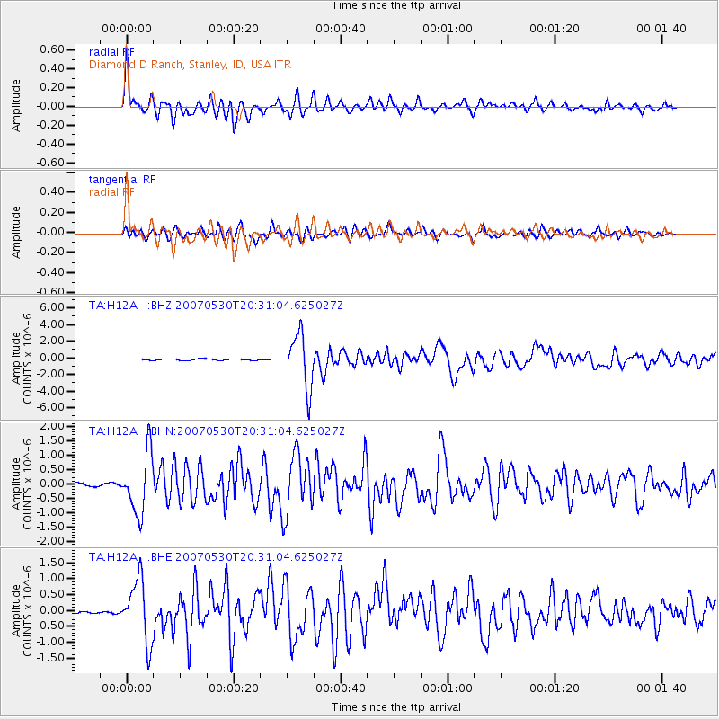
H12A Diamond D Ranch, Stanley, ID, USA |
| Lat/Lon: |
44.55 N/114.86 W |
| Elevation: |
1777 m |
|
| Distance: |
55.5 deg |
| Az: |
60.164 deg |
| Baz: |
311.603 deg |
| Ray Param: |
0.064422384 |
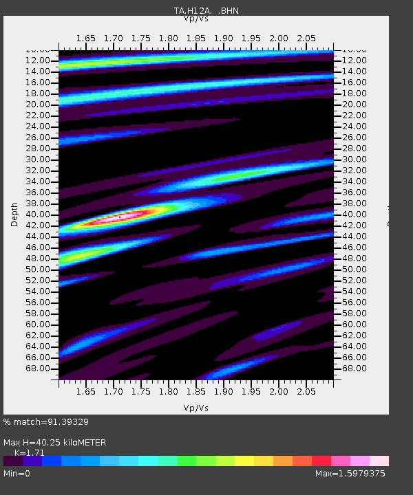
| Estimated Moho Depth: |
40.25 km |
| Estimated Crust Vp/Vs: |
1.71 |
| Assumed Crust Vp: |
6.577 km/s |
| Estimated Crust Vs: |
3.846 km/s |
| Estimated Crust Poisson's Ratio: |
0.24 |
|
| Radial Match: |
91.39329 % |
| Radial Bump: |
400 |
| Transverse Match: |
82.91303 % |
| Transverse Bump: |
400 |
| SOD ConfigId: |
2564 |
| Insert Time: |
2010-03-06 05:15:57.250 +0000 |
| GWidth: |
2.5 |
| Max Bumps: |
400 |
| Tol: |
0.001 |
|
Signal To Noise
| Channel | StoN | STA | LTA |
| TA:H12A: :BHN:20070530T20:31:04.625027Z | 16.906618 | 1.0517313E-6 | 6.2208265E-8 |
| TA:H12A: :BHE:20070530T20:31:04.625027Z | 17.477867 | 9.816546E-7 | 5.616558E-8 |
| TA:H12A: :BHZ:20070530T20:31:04.625027Z | 36.262897 | 3.1733425E-6 | 8.750935E-8 |
| Arrivals |
| Ps | 4.6 SECOND |
| PpPs | 16 SECOND |
| PsPs/PpSs | 20 SECOND |


