You are here: Home > Network List > TA - USArray Transportable Network (new EarthScope stations) Stations List
> Station H12A Diamond D Ranch, Stanley, ID, USA > Earthquake Result Viewer
H12A Diamond D Ranch, Stanley, ID, USA - Earthquake Result Viewer
| Earthquake location: |
Near Coast Of Guatemala |
| Earthquake latitude/longitude: |
13.6/-90.6 |
| Earthquake time(UTC): |
2008/04/15 (106) 03:03:04 GMT |
| Earthquake Depth: |
33 km |
| Earthquake Magnitude: |
5.6 MB, 5.8 MS, 6.1 MW, 6.1 MW |
| Earthquake Catalog/Contributor: |
WHDF/NEIC |
|
| Network: |
TA USArray Transportable Network (new EarthScope stations) |
| Station: |
H12A Diamond D Ranch, Stanley, ID, USA |
| Lat/Lon: |
44.55 N/114.86 W |
| Elevation: |
1777 m |
|
| Distance: |
37.2 deg |
| Az: |
330.91 deg |
| Baz: |
138.605 deg |
| Ray Param: |
0.07622137 |
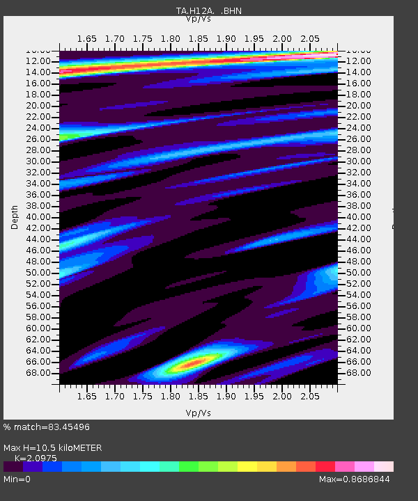
| Estimated Moho Depth: |
10.5 km |
| Estimated Crust Vp/Vs: |
2.10 |
| Assumed Crust Vp: |
6.577 km/s |
| Estimated Crust Vs: |
3.136 km/s |
| Estimated Crust Poisson's Ratio: |
0.35 |
|
| Radial Match: |
83.45496 % |
| Radial Bump: |
383 |
| Transverse Match: |
61.954685 % |
| Transverse Bump: |
400 |
| SOD ConfigId: |
2504 |
| Insert Time: |
2010-03-06 05:16:08.824 +0000 |
| GWidth: |
2.5 |
| Max Bumps: |
400 |
| Tol: |
0.001 |
|
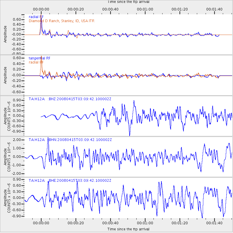
Signal To Noise
| Channel | StoN | STA | LTA |
| TA:H12A: :BHN:20080415T03:09:42.100002Z | 5.100614 | 9.2851843E-7 | 1.8204051E-7 |
| TA:H12A: :BHE:20080415T03:09:42.100002Z | 2.3583713 | 3.3112667E-7 | 1.4040481E-7 |
| TA:H12A: :BHZ:20080415T03:09:42.100002Z | 3.9269838 | 3.136671E-7 | 7.9874816E-8 |
| Arrivals |
| Ps | 1.9 SECOND |
| PpPs | 4.6 SECOND |
| PsPs/PpSs | 6.5 SECOND |


