You are here: Home > Network List > TA - USArray Transportable Network (new EarthScope stations) Stations List
> Station H12A Diamond D Ranch, Stanley, ID, USA > Earthquake Result Viewer
H12A Diamond D Ranch, Stanley, ID, USA - Earthquake Result Viewer
| Earthquake location: |
South Of Mariana Islands |
| Earthquake latitude/longitude: |
12.5/143.2 |
| Earthquake time(UTC): |
2008/05/09 (130) 21:51:29 GMT |
| Earthquake Depth: |
76 km |
| Earthquake Magnitude: |
6.1 MB, 6.7 MW, 6.7 MW |
| Earthquake Catalog/Contributor: |
WHDF/NEIC |
|
| Network: |
TA USArray Transportable Network (new EarthScope stations) |
| Station: |
H12A Diamond D Ranch, Stanley, ID, USA |
| Lat/Lon: |
44.55 N/114.86 W |
| Elevation: |
1777 m |
|
| Distance: |
89.7 deg |
| Az: |
44.385 deg |
| Baz: |
287.187 deg |
| Ray Param: |
0.04171446 |
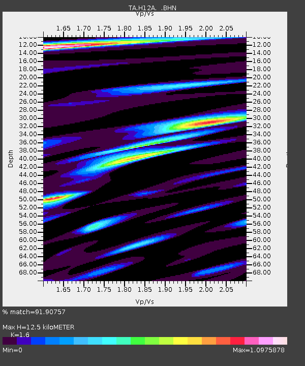
| Estimated Moho Depth: |
12.5 km |
| Estimated Crust Vp/Vs: |
1.60 |
| Assumed Crust Vp: |
6.577 km/s |
| Estimated Crust Vs: |
4.111 km/s |
| Estimated Crust Poisson's Ratio: |
0.18 |
|
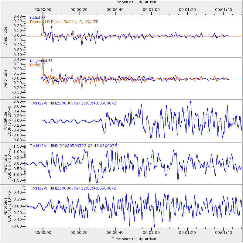
| Radial Match: |
91.90757 % |
| Radial Bump: |
400 |
| Transverse Match: |
82.704056 % |
| Transverse Bump: |
400 |
| SOD ConfigId: |
2504 |
| Insert Time: |
2010-03-06 05:16:19.733 +0000 |
| GWidth: |
2.5 |
| Max Bumps: |
400 |
| Tol: |
0.001 |
|
Signal To Noise
| Channel | StoN | STA | LTA |
| TA:H12A: :BHN:20080509T22:03:48.050007Z | 7.5780754 | 4.9949557E-7 | 6.591325E-8 |
| TA:H12A: :BHE:20080509T22:03:48.050007Z | 2.167078 | 8.380514E-8 | 3.8671953E-8 |
| TA:H12A: :BHZ:20080509T22:03:48.050007Z | 4.513433 | 2.0858859E-7 | 4.621506E-8 |
| Arrivals |
| Ps | 1.2 SECOND |
| PpPs | 4.8 SECOND |
| PsPs/PpSs | 6.0 SECOND |


