You are here: Home > Network List > TA - USArray Transportable Network (new EarthScope stations) Stations List
> Station H12A Diamond D Ranch, Stanley, ID, USA > Earthquake Result Viewer
H12A Diamond D Ranch, Stanley, ID, USA - Earthquake Result Viewer
| Earthquake location: |
Fiji Islands Region |
| Earthquake latitude/longitude: |
-17.3/-177.3 |
| Earthquake time(UTC): |
2008/07/19 (201) 22:39:52 GMT |
| Earthquake Depth: |
391 km |
| Earthquake Magnitude: |
5.9 MB, 6.4 MW, 6.4 MW |
| Earthquake Catalog/Contributor: |
WHDF/NEIC |
|
| Network: |
TA USArray Transportable Network (new EarthScope stations) |
| Station: |
H12A Diamond D Ranch, Stanley, ID, USA |
| Lat/Lon: |
44.55 N/114.86 W |
| Elevation: |
1777 m |
|
| Distance: |
83.8 deg |
| Az: |
39.624 deg |
| Baz: |
238.422 deg |
| Ray Param: |
0.044915482 |
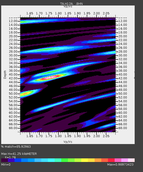
| Estimated Moho Depth: |
41.25 km |
| Estimated Crust Vp/Vs: |
1.76 |
| Assumed Crust Vp: |
6.577 km/s |
| Estimated Crust Vs: |
3.737 km/s |
| Estimated Crust Poisson's Ratio: |
0.26 |
|
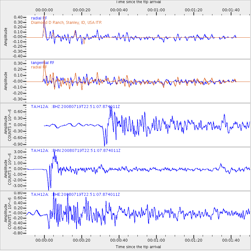
| Radial Match: |
85.92963 % |
| Radial Bump: |
400 |
| Transverse Match: |
71.859116 % |
| Transverse Bump: |
400 |
| SOD ConfigId: |
2504 |
| Insert Time: |
2010-03-06 05:16:38.272 +0000 |
| GWidth: |
2.5 |
| Max Bumps: |
400 |
| Tol: |
0.001 |
|
Signal To Noise
| Channel | StoN | STA | LTA |
| TA:H12A: :BHN:20080719T22:51:07.874011Z | 16.412287 | 1.5460913E-6 | 9.420329E-8 |
| TA:H12A: :BHE:20080719T22:51:07.874011Z | 5.908878 | 2.2347125E-7 | 3.7819575E-8 |
| TA:H12A: :BHZ:20080719T22:51:07.874011Z | 8.320552 | 4.039116E-7 | 4.854385E-8 |
| Arrivals |
| Ps | 4.9 SECOND |
| PpPs | 17 SECOND |
| PsPs/PpSs | 22 SECOND |


