You are here: Home > Network List > CI - Caltech Regional Seismic Network Stations List
> Station SMM Simmler, CA, USA > Earthquake Result Viewer
SMM Simmler, CA, USA - Earthquake Result Viewer
*The percent match for this event was below the threshold and hence no stack was calculated.
| Earthquake location: |
Tonga Islands |
| Earthquake latitude/longitude: |
-16.8/-173.5 |
| Earthquake time(UTC): |
2009/05/17 (137) 06:23:03 GMT |
| Earthquake Depth: |
67 km |
| Earthquake Magnitude: |
5.5 MB, 5.6 MW, 5.6 MW |
| Earthquake Catalog/Contributor: |
WHDF/NEIC |
|
| Network: |
CI Caltech Regional Seismic Network |
| Station: |
SMM Simmler, CA, USA |
| Lat/Lon: |
35.31 N/120.00 W |
| Elevation: |
599 m |
|
| Distance: |
72.5 deg |
| Az: |
43.567 deg |
| Baz: |
233.814 deg |
| Ray Param: |
$rayparam |
*The percent match for this event was below the threshold and hence was not used in the summary stack. |
|
| Radial Match: |
52.719105 % |
| Radial Bump: |
400 |
| Transverse Match: |
50.707905 % |
| Transverse Bump: |
400 |
| SOD ConfigId: |
2760 |
| Insert Time: |
2010-02-26 01:32:12.482 +0000 |
| GWidth: |
2.5 |
| Max Bumps: |
400 |
| Tol: |
0.001 |
|
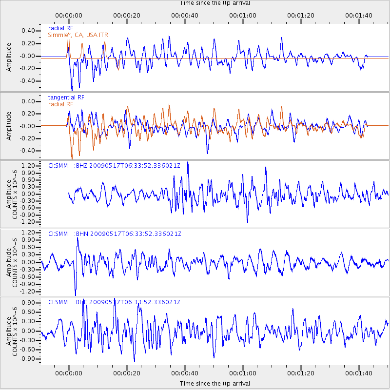
Signal To Noise
| Channel | StoN | STA | LTA |
| CI:SMM: :BHN:20090517T06:33:52.336021Z | 2.8703768 | 5.029652E-7 | 1.7522619E-7 |
| CI:SMM: :BHE:20090517T06:33:52.336021Z | 1.3683687 | 3.3913756E-7 | 2.4784077E-7 |
| CI:SMM: :BHZ:20090517T06:33:52.336021Z | 0.7706742 | 1.7203183E-7 | 2.2322251E-7 |
| Arrivals |
| Ps | |
| PpPs | |
| PsPs/PpSs | |


