You are here: Home > Network List > TA - USArray Transportable Network (new EarthScope stations) Stations List
> Station H12A Diamond D Ranch, Stanley, ID, USA > Earthquake Result Viewer
H12A Diamond D Ranch, Stanley, ID, USA - Earthquake Result Viewer
| Earthquake location: |
Santiago Del Estero Prov., Arg. |
| Earthquake latitude/longitude: |
-26.7/-63.2 |
| Earthquake time(UTC): |
2008/09/03 (247) 11:25:14 GMT |
| Earthquake Depth: |
570 km |
| Earthquake Magnitude: |
5.9 MB, 6.3 MW, 6.3 MW |
| Earthquake Catalog/Contributor: |
WHDF/NEIC |
|
| Network: |
TA USArray Transportable Network (new EarthScope stations) |
| Station: |
H12A Diamond D Ranch, Stanley, ID, USA |
| Lat/Lon: |
44.55 N/114.86 W |
| Elevation: |
1777 m |
|
| Distance: |
85.2 deg |
| Az: |
325.767 deg |
| Baz: |
135.28 deg |
| Ray Param: |
0.043311767 |
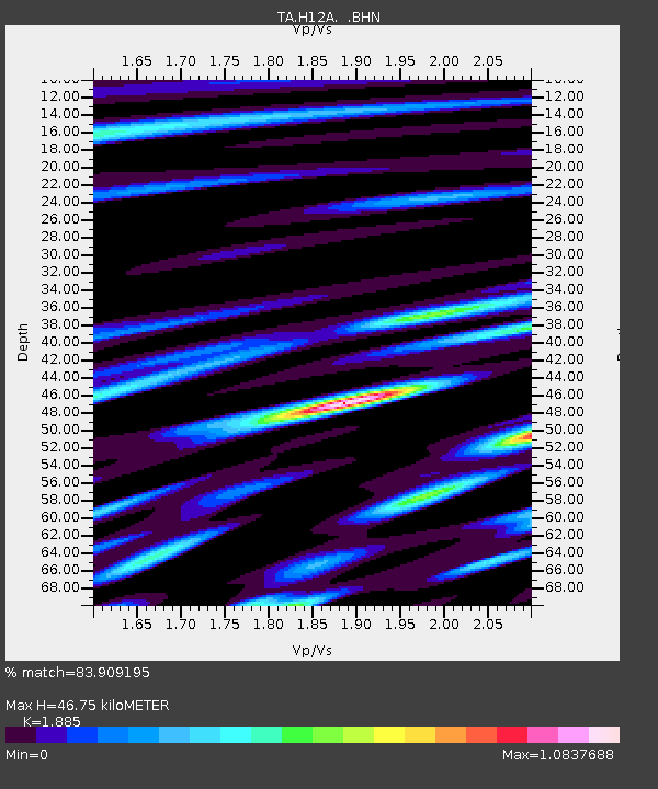
| Estimated Moho Depth: |
46.75 km |
| Estimated Crust Vp/Vs: |
1.88 |
| Assumed Crust Vp: |
6.577 km/s |
| Estimated Crust Vs: |
3.489 km/s |
| Estimated Crust Poisson's Ratio: |
0.30 |
|
| Radial Match: |
83.909195 % |
| Radial Bump: |
392 |
| Transverse Match: |
71.24422 % |
| Transverse Bump: |
400 |
| SOD ConfigId: |
2504 |
| Insert Time: |
2010-03-06 05:16:59.098 +0000 |
| GWidth: |
2.5 |
| Max Bumps: |
400 |
| Tol: |
0.001 |
|
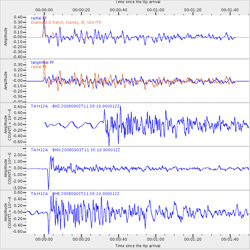
Signal To Noise
| Channel | StoN | STA | LTA |
| TA:H12A: :BHN:20080903T11:36:19.900012Z | 27.384579 | 1.1272807E-6 | 4.11648E-8 |
| TA:H12A: :BHE:20080903T11:36:19.900012Z | 5.8106036 | 2.4283932E-7 | 4.1792443E-8 |
| TA:H12A: :BHZ:20080903T11:36:19.900012Z | 3.7545314 | 2.1898583E-7 | 5.832574E-8 |
| Arrivals |
| Ps | 6.4 SECOND |
| PpPs | 20 SECOND |
| PsPs/PpSs | 26 SECOND |


