You are here: Home > Network List > TA - USArray Transportable Network (new EarthScope stations) Stations List
> Station H12A Diamond D Ranch, Stanley, ID, USA > Earthquake Result Viewer
H12A Diamond D Ranch, Stanley, ID, USA - Earthquake Result Viewer
| Earthquake location: |
Central Mid-Atlantic Ridge |
| Earthquake latitude/longitude: |
8.1/-38.7 |
| Earthquake time(UTC): |
2008/09/10 (254) 13:08:14 GMT |
| Earthquake Depth: |
10 km |
| Earthquake Magnitude: |
6.3 MB, 6.5 MS, 6.6 MW, 6.6 MW |
| Earthquake Catalog/Contributor: |
WHDF/NEIC |
|
| Network: |
TA USArray Transportable Network (new EarthScope stations) |
| Station: |
H12A Diamond D Ranch, Stanley, ID, USA |
| Lat/Lon: |
44.55 N/114.86 W |
| Elevation: |
1777 m |
|
| Distance: |
74.5 deg |
| Az: |
313.912 deg |
| Baz: |
93.92 deg |
| Ray Param: |
0.05229794 |
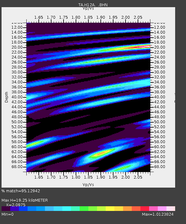
| Estimated Moho Depth: |
19.25 km |
| Estimated Crust Vp/Vs: |
2.10 |
| Assumed Crust Vp: |
6.577 km/s |
| Estimated Crust Vs: |
3.136 km/s |
| Estimated Crust Poisson's Ratio: |
0.35 |
|
| Radial Match: |
95.12942 % |
| Radial Bump: |
378 |
| Transverse Match: |
88.2501 % |
| Transverse Bump: |
400 |
| SOD ConfigId: |
2560 |
| Insert Time: |
2010-03-06 05:17:06.799 +0000 |
| GWidth: |
2.5 |
| Max Bumps: |
400 |
| Tol: |
0.001 |
|
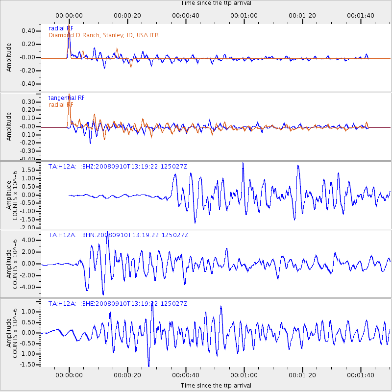
Signal To Noise
| Channel | StoN | STA | LTA |
| TA:H12A: :BHN:20080910T13:19:22.125027Z | 2.9557984 | 2.8534802E-7 | 9.65384E-8 |
| TA:H12A: :BHE:20080910T13:19:22.125027Z | 1.7393061 | 1.8442286E-7 | 1.0603244E-7 |
| TA:H12A: :BHZ:20080910T13:19:22.125027Z | 2.0977848 | 1.2381764E-7 | 5.9023044E-8 |
| Arrivals |
| Ps | 3.3 SECOND |
| PpPs | 8.8 SECOND |
| PsPs/PpSs | 12 SECOND |


