You are here: Home > Network List > TA - USArray Transportable Network (new EarthScope stations) Stations List
> Station H12A Diamond D Ranch, Stanley, ID, USA > Earthquake Result Viewer
H12A Diamond D Ranch, Stanley, ID, USA - Earthquake Result Viewer
| Earthquake location: |
Northern Mid-Atlantic Ridge |
| Earthquake latitude/longitude: |
23.9/-46.1 |
| Earthquake time(UTC): |
2009/06/06 (157) 20:33:28 GMT |
| Earthquake Depth: |
14 km |
| Earthquake Magnitude: |
6.0 MB, 5.7 MS, 6.0 MW, 6.0 MW |
| Earthquake Catalog/Contributor: |
WHDF/NEIC |
|
| Network: |
TA USArray Transportable Network (new EarthScope stations) |
| Station: |
H12A Diamond D Ranch, Stanley, ID, USA |
| Lat/Lon: |
44.55 N/114.86 W |
| Elevation: |
1777 m |
|
| Distance: |
58.8 deg |
| Az: |
308.801 deg |
| Baz: |
86.267 deg |
| Ray Param: |
0.062619954 |
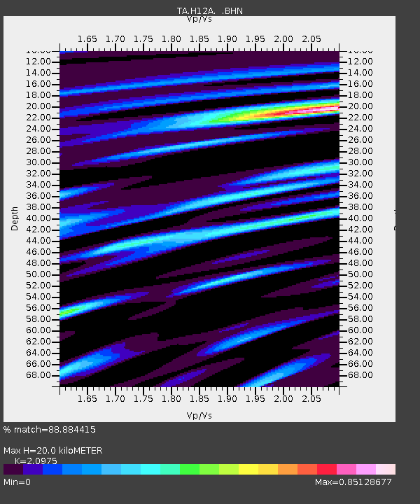
| Estimated Moho Depth: |
20.0 km |
| Estimated Crust Vp/Vs: |
2.10 |
| Assumed Crust Vp: |
6.577 km/s |
| Estimated Crust Vs: |
3.136 km/s |
| Estimated Crust Poisson's Ratio: |
0.35 |
|
| Radial Match: |
88.884415 % |
| Radial Bump: |
400 |
| Transverse Match: |
75.8592 % |
| Transverse Bump: |
400 |
| SOD ConfigId: |
2648 |
| Insert Time: |
2010-03-06 05:17:39.284 +0000 |
| GWidth: |
2.5 |
| Max Bumps: |
400 |
| Tol: |
0.001 |
|
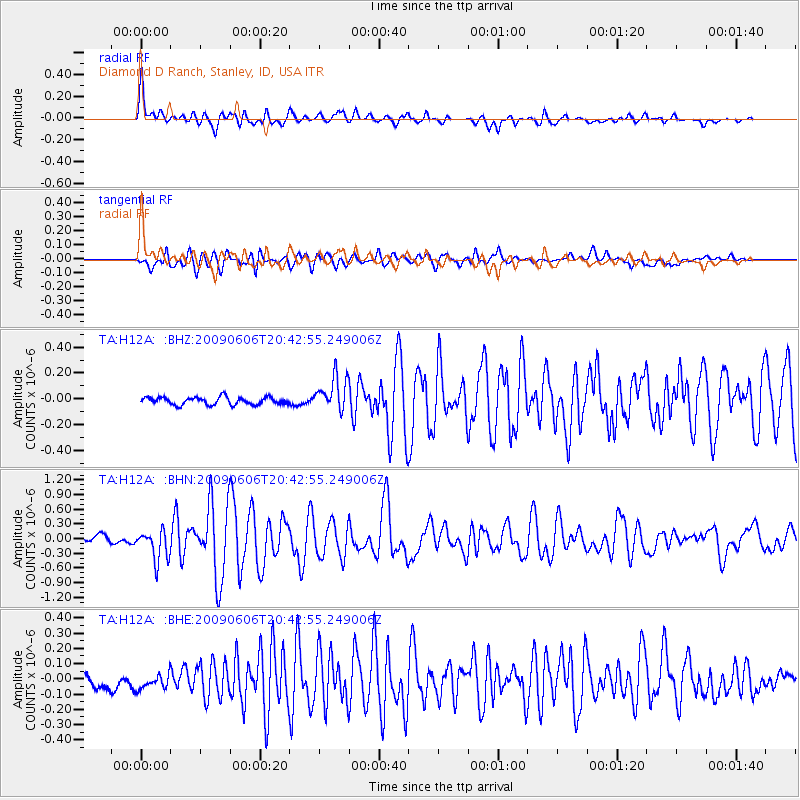
Signal To Noise
| Channel | StoN | STA | LTA |
| TA:H12A: :BHN:20090606T20:42:55.249006Z | 4.4058228 | 3.0935448E-7 | 7.021492E-8 |
| TA:H12A: :BHE:20090606T20:42:55.249006Z | 1.2606667 | 5.09213E-8 | 4.0392358E-8 |
| TA:H12A: :BHZ:20090606T20:42:55.249006Z | 4.567176 | 1.3103724E-7 | 2.8691087E-8 |
| Arrivals |
| Ps | 3.5 SECOND |
| PpPs | 9.0 SECOND |
| PsPs/PpSs | 13 SECOND |


