You are here: Home > Network List > TA - USArray Transportable Network (new EarthScope stations) Stations List
> Station H12A Diamond D Ranch, Stanley, ID, USA > Earthquake Result Viewer
H12A Diamond D Ranch, Stanley, ID, USA - Earthquake Result Viewer
| Earthquake location: |
Honduras |
| Earthquake latitude/longitude: |
15.8/-86.9 |
| Earthquake time(UTC): |
2009/06/08 (159) 05:13:14 GMT |
| Earthquake Depth: |
10 km |
| Earthquake Magnitude: |
5.5 MB, 4.9 MS, 5.4 MW, 5.4 MW |
| Earthquake Catalog/Contributor: |
WHDF/NEIC |
|
| Network: |
TA USArray Transportable Network (new EarthScope stations) |
| Station: |
H12A Diamond D Ranch, Stanley, ID, USA |
| Lat/Lon: |
44.55 N/114.86 W |
| Elevation: |
1777 m |
|
| Distance: |
37.2 deg |
| Az: |
326.256 deg |
| Baz: |
131.586 deg |
| Ray Param: |
0.07628548 |
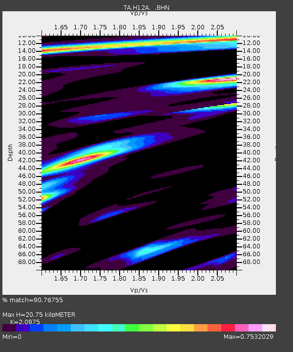
| Estimated Moho Depth: |
20.75 km |
| Estimated Crust Vp/Vs: |
2.10 |
| Assumed Crust Vp: |
6.577 km/s |
| Estimated Crust Vs: |
3.136 km/s |
| Estimated Crust Poisson's Ratio: |
0.35 |
|
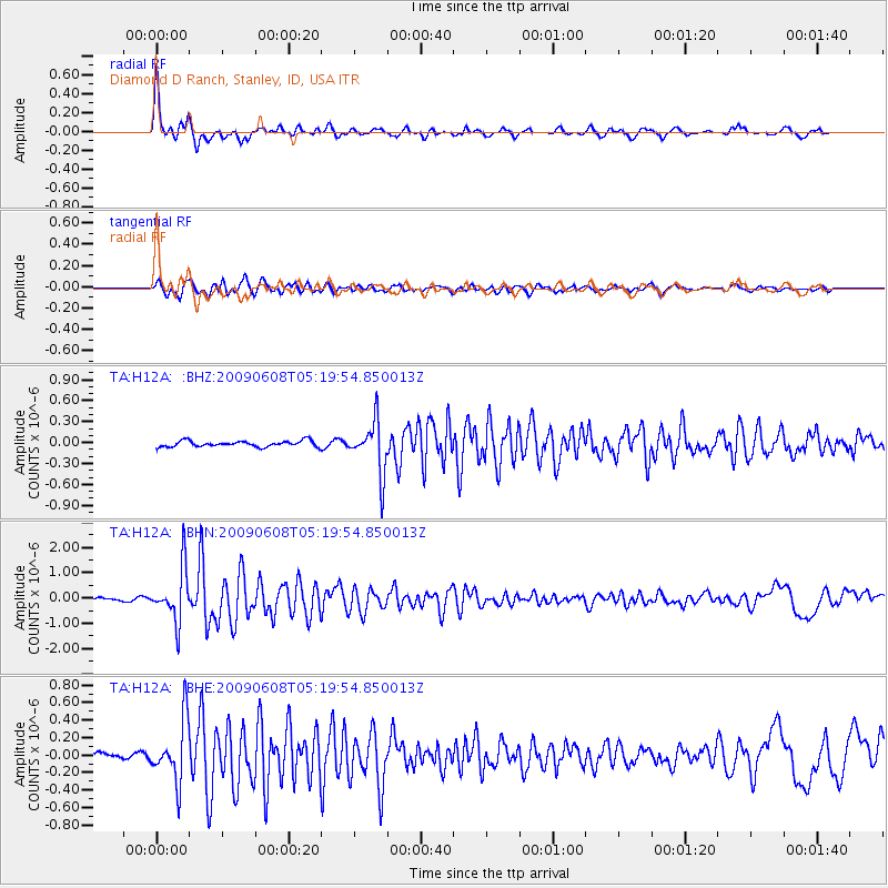
| Radial Match: |
90.76755 % |
| Radial Bump: |
400 |
| Transverse Match: |
83.61164 % |
| Transverse Bump: |
400 |
| SOD ConfigId: |
2648 |
| Insert Time: |
2010-03-06 05:17:43.164 +0000 |
| GWidth: |
2.5 |
| Max Bumps: |
400 |
| Tol: |
0.001 |
|
Signal To Noise
| Channel | StoN | STA | LTA |
| TA:H12A: :BHN:20090608T05:19:54.850013Z | 13.938302 | 1.0507403E-6 | 7.5385095E-8 |
| TA:H12A: :BHE:20090608T05:19:54.850013Z | 5.2657366 | 3.502543E-7 | 6.651573E-8 |
| TA:H12A: :BHZ:20090608T05:19:54.850013Z | 8.857599 | 3.7444624E-7 | 4.227401E-8 |
| Arrivals |
| Ps | 3.7 SECOND |
| PpPs | 9.2 SECOND |
| PsPs/PpSs | 13 SECOND |


