You are here: Home > Network List > TA - USArray Transportable Network (new EarthScope stations) Stations List
> Station H12A Diamond D Ranch, Stanley, ID, USA > Earthquake Result Viewer
H12A Diamond D Ranch, Stanley, ID, USA - Earthquake Result Viewer
| Earthquake location: |
Baffin Bay |
| Earthquake latitude/longitude: |
75.4/-72.5 |
| Earthquake time(UTC): |
2009/07/07 (188) 19:11:46 GMT |
| Earthquake Depth: |
19 km |
| Earthquake Magnitude: |
5.9 MB, 5.7 MS, 6.1 MW, 6.0 MW |
| Earthquake Catalog/Contributor: |
WHDF/NEIC |
|
| Network: |
TA USArray Transportable Network (new EarthScope stations) |
| Station: |
H12A Diamond D Ranch, Stanley, ID, USA |
| Lat/Lon: |
44.55 N/114.86 W |
| Elevation: |
1777 m |
|
| Distance: |
35.9 deg |
| Az: |
235.395 deg |
| Baz: |
17.036 deg |
| Ray Param: |
0.07697457 |
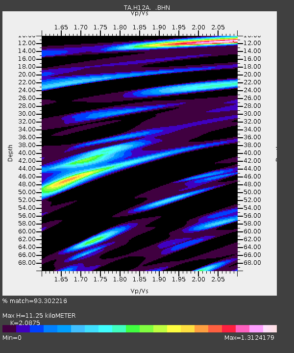
| Estimated Moho Depth: |
11.25 km |
| Estimated Crust Vp/Vs: |
2.09 |
| Assumed Crust Vp: |
6.577 km/s |
| Estimated Crust Vs: |
3.151 km/s |
| Estimated Crust Poisson's Ratio: |
0.35 |
|
| Radial Match: |
93.302216 % |
| Radial Bump: |
394 |
| Transverse Match: |
85.161514 % |
| Transverse Bump: |
400 |
| SOD ConfigId: |
2648 |
| Insert Time: |
2010-03-06 05:17:46.820 +0000 |
| GWidth: |
2.5 |
| Max Bumps: |
400 |
| Tol: |
0.001 |
|
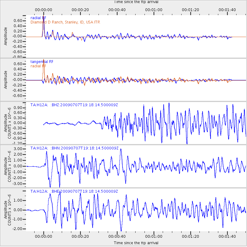
Signal To Noise
| Channel | StoN | STA | LTA |
| TA:H12A: :BHN:20090707T19:18:14.500009Z | 30.469467 | 1.6878319E-6 | 5.5394203E-8 |
| TA:H12A: :BHE:20090707T19:18:14.500009Z | 17.45876 | 9.117258E-7 | 5.2221687E-8 |
| TA:H12A: :BHZ:20090707T19:18:14.500009Z | 4.5888186 | 1.8501541E-7 | 4.031875E-8 |
| Arrivals |
| Ps | 2.0 SECOND |
| PpPs | 4.9 SECOND |
| PsPs/PpSs | 6.9 SECOND |


