You are here: Home > Network List > TA - USArray Transportable Network (new EarthScope stations) Stations List
> Station H12A Diamond D Ranch, Stanley, ID, USA > Earthquake Result Viewer
H12A Diamond D Ranch, Stanley, ID, USA - Earthquake Result Viewer
| Earthquake location: |
Southeast Of Loyalty Islands |
| Earthquake latitude/longitude: |
-22.6/170.9 |
| Earthquake time(UTC): |
2009/01/19 (019) 03:35:18 GMT |
| Earthquake Depth: |
12 km |
| Earthquake Magnitude: |
5.7 MB, 6.4 MS, 6.5 MW, 6.5 MW |
| Earthquake Catalog/Contributor: |
WHDF/NEIC |
|
| Network: |
TA USArray Transportable Network (new EarthScope stations) |
| Station: |
H12A Diamond D Ranch, Stanley, ID, USA |
| Lat/Lon: |
44.55 N/114.86 W |
| Elevation: |
1777 m |
|
| Distance: |
95.0 deg |
| Az: |
43.69 deg |
| Baz: |
243.228 deg |
| Ray Param: |
0.040891446 |
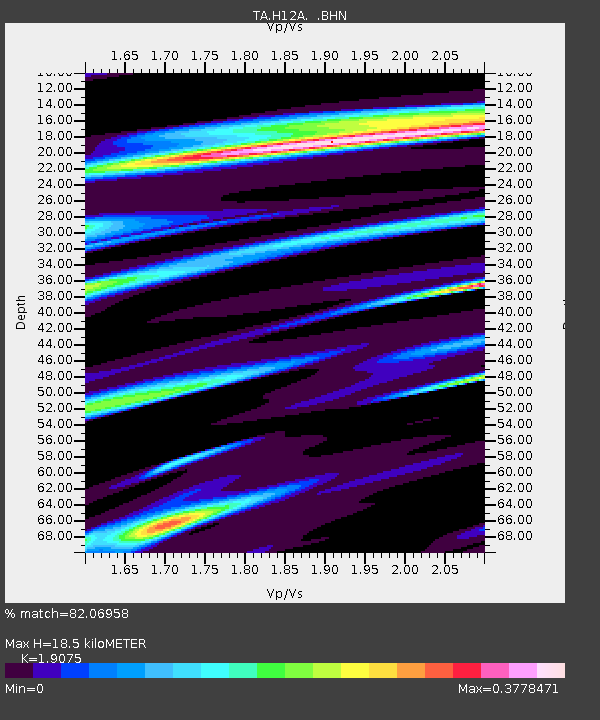
| Estimated Moho Depth: |
18.5 km |
| Estimated Crust Vp/Vs: |
1.91 |
| Assumed Crust Vp: |
6.577 km/s |
| Estimated Crust Vs: |
3.448 km/s |
| Estimated Crust Poisson's Ratio: |
0.31 |
|
| Radial Match: |
82.06958 % |
| Radial Bump: |
343 |
| Transverse Match: |
68.69749 % |
| Transverse Bump: |
400 |
| SOD ConfigId: |
2658 |
| Insert Time: |
2010-03-06 05:17:54.100 +0000 |
| GWidth: |
2.5 |
| Max Bumps: |
400 |
| Tol: |
0.001 |
|
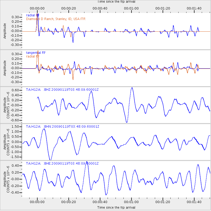
Signal To Noise
| Channel | StoN | STA | LTA |
| TA:H12A: :BHN:20090119T03:48:09.60001Z | 7.174499 | 7.7693915E-7 | 1.08291765E-7 |
| TA:H12A: :BHE:20090119T03:48:09.60001Z | 1.925446 | 2.0623685E-7 | 1.0711121E-7 |
| TA:H12A: :BHZ:20090119T03:48:09.60001Z | 1.8596123 | 2.933219E-7 | 1.5773283E-7 |
| Arrivals |
| Ps | 2.6 SECOND |
| PpPs | 8.0 SECOND |
| PsPs/PpSs | 11 SECOND |


