You are here: Home > Network List > TA - USArray Transportable Network (new EarthScope stations) Stations List
> Station O17K Koliganek, Bristol Bay, AK, USA > Earthquake Result Viewer
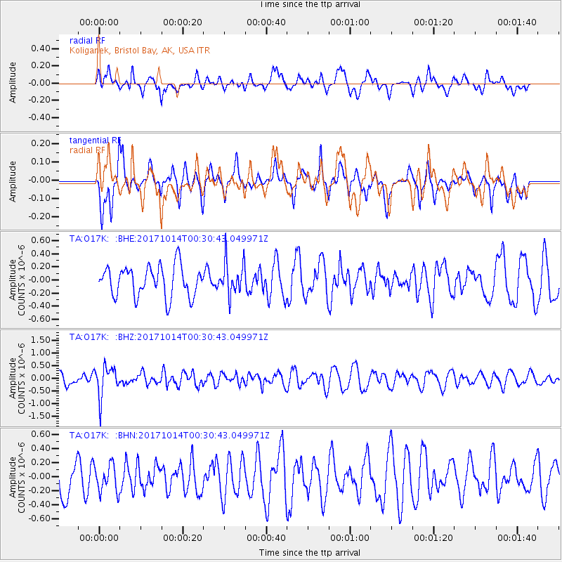
O17K Koliganek, Bristol Bay, AK, USA - Earthquake Result Viewer
*The percent match for this event was below the threshold and hence no stack was calculated.
| Earthquake location: |
Oaxaca, Mexico |
| Earthquake latitude/longitude: |
16.2/-94.8 |
| Earthquake time(UTC): |
2017/10/14 (287) 00:20:57 GMT |
| Earthquake Depth: |
49 km |
| Earthquake Magnitude: |
5.5 Mww |
| Earthquake Catalog/Contributor: |
NEIC PDE/us |
|
| Network: |
TA USArray Transportable Network (new EarthScope stations) |
| Station: |
O17K Koliganek, Bristol Bay, AK, USA |
| Lat/Lon: |
59.77 N/157.09 W |
| Elevation: |
156 m |
|
| Distance: |
62.3 deg |
| Az: |
329.595 deg |
| Baz: |
106.063 deg |
| Ray Param: |
$rayparam |
*The percent match for this event was below the threshold and hence was not used in the summary stack. |
|
| Radial Match: |
59.9323 % |
| Radial Bump: |
400 |
| Transverse Match: |
47.601654 % |
| Transverse Bump: |
394 |
| SOD ConfigId: |
13570011 |
| Insert Time: |
2019-04-28 23:52:21.161 +0000 |
| GWidth: |
2.5 |
| Max Bumps: |
400 |
| Tol: |
0.001 |
|
Signal To Noise
| Channel | StoN | STA | LTA |
| TA:O17K: :BHZ:20171014T00:30:43.049971Z | 2.292412 | 6.130654E-7 | 2.6743248E-7 |
| TA:O17K: :BHN:20171014T00:30:43.049971Z | 0.6550947 | 1.9381143E-7 | 2.9585254E-7 |
| TA:O17K: :BHE:20171014T00:30:43.049971Z | 1.1285019 | 2.6160976E-7 | 2.318204E-7 |
| Arrivals |
| Ps | |
| PpPs | |
| PsPs/PpSs | |


