You are here: Home > Network List > TA - USArray Transportable Network (new EarthScope stations) Stations List
> Station R33M Jennings River, BC, CAN > Earthquake Result Viewer
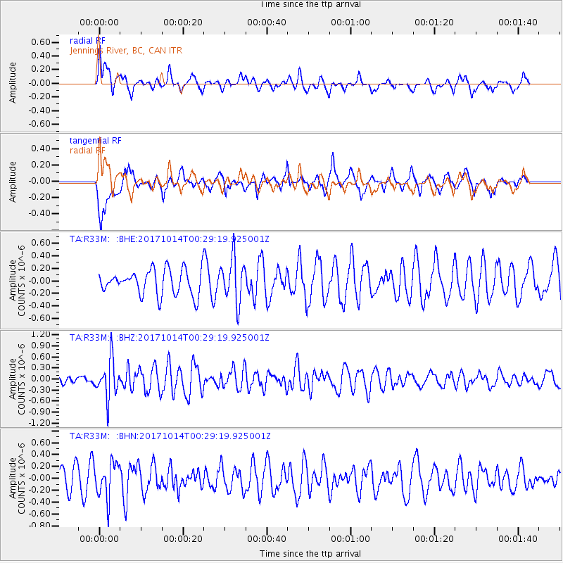
R33M Jennings River, BC, CAN - Earthquake Result Viewer
*The percent match for this event was below the threshold and hence no stack was calculated.
| Earthquake location: |
Oaxaca, Mexico |
| Earthquake latitude/longitude: |
16.2/-94.8 |
| Earthquake time(UTC): |
2017/10/14 (287) 00:20:57 GMT |
| Earthquake Depth: |
49 km |
| Earthquake Magnitude: |
5.5 Mww |
| Earthquake Catalog/Contributor: |
NEIC PDE/us |
|
| Network: |
TA USArray Transportable Network (new EarthScope stations) |
| Station: |
R33M Jennings River, BC, CAN |
| Lat/Lon: |
59.39 N/130.97 W |
| Elevation: |
1437 m |
|
| Distance: |
50.5 deg |
| Az: |
336.985 deg |
| Baz: |
132.772 deg |
| Ray Param: |
$rayparam |
*The percent match for this event was below the threshold and hence was not used in the summary stack. |
|
| Radial Match: |
53.482388 % |
| Radial Bump: |
400 |
| Transverse Match: |
58.2971 % |
| Transverse Bump: |
400 |
| SOD ConfigId: |
13570011 |
| Insert Time: |
2019-04-28 23:52:30.183 +0000 |
| GWidth: |
2.5 |
| Max Bumps: |
400 |
| Tol: |
0.001 |
|
Signal To Noise
| Channel | StoN | STA | LTA |
| TA:R33M: :BHZ:20171014T00:29:19.925001Z | 4.1695256 | 5.364582E-7 | 1.2866168E-7 |
| TA:R33M: :BHN:20171014T00:29:19.925001Z | 1.5472732 | 3.0434683E-7 | 1.9669883E-7 |
| TA:R33M: :BHE:20171014T00:29:19.925001Z | 1.7808067 | 3.604462E-7 | 2.0240614E-7 |
| Arrivals |
| Ps | |
| PpPs | |
| PsPs/PpSs | |


