You are here: Home > Network List > AV - Alaska Volcano Observatory Stations List
> Station SPCR Ckakachatna River, Mount Spurr, Alaska > Earthquake Result Viewer
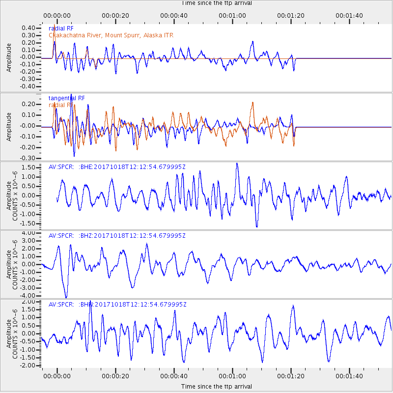
SPCR Ckakachatna River, Mount Spurr, Alaska - Earthquake Result Viewer
*The percent match for this event was below the threshold and hence no stack was calculated.
| Earthquake location: |
Tonga Islands |
| Earthquake latitude/longitude: |
-20.6/-173.9 |
| Earthquake time(UTC): |
2017/10/18 (291) 12:00:59 GMT |
| Earthquake Depth: |
10 km |
| Earthquake Magnitude: |
6.0 Mww |
| Earthquake Catalog/Contributor: |
NEIC PDE/us |
|
| Network: |
AV Alaska Volcano Observatory |
| Station: |
SPCR Ckakachatna River, Mount Spurr, Alaska |
| Lat/Lon: |
61.20 N/152.21 W |
| Elevation: |
984 m |
|
| Distance: |
83.4 deg |
| Az: |
10.378 deg |
| Baz: |
200.396 deg |
| Ray Param: |
$rayparam |
*The percent match for this event was below the threshold and hence was not used in the summary stack. |
|
| Radial Match: |
69.33004 % |
| Radial Bump: |
376 |
| Transverse Match: |
57.48918 % |
| Transverse Bump: |
400 |
| SOD ConfigId: |
13570011 |
| Insert Time: |
2019-04-28 23:55:39.338 +0000 |
| GWidth: |
2.5 |
| Max Bumps: |
400 |
| Tol: |
0.001 |
|
Signal To Noise
| Channel | StoN | STA | LTA |
| AV:SPCR: :BHZ:20171018T12:12:54.679995Z | 5.698133 | 2.3023576E-6 | 4.0405473E-7 |
| AV:SPCR: :BHN:20171018T12:12:54.679995Z | 0.8273383 | 4.0629553E-7 | 4.910875E-7 |
| AV:SPCR: :BHE:20171018T12:12:54.679995Z | 1.0116341 | 4.5175696E-7 | 4.4656161E-7 |
| Arrivals |
| Ps | |
| PpPs | |
| PsPs/PpSs | |


