You are here: Home > Network List > CC - Cascade Chain Volcano Monitoring Stations List
> Station VALT Mt. St. Helens Crater, WA > Earthquake Result Viewer
VALT Mt. St. Helens Crater, WA - Earthquake Result Viewer
| Earthquake location: |
Tonga Islands |
| Earthquake latitude/longitude: |
-20.6/-173.9 |
| Earthquake time(UTC): |
2017/10/18 (291) 12:00:59 GMT |
| Earthquake Depth: |
10 km |
| Earthquake Magnitude: |
6.0 Mww |
| Earthquake Catalog/Contributor: |
NEIC PDE/us |
|
| Network: |
CC Cascade Chain Volcano Monitoring |
| Station: |
VALT Mt. St. Helens Crater, WA |
| Lat/Lon: |
46.21 N/122.19 W |
| Elevation: |
1681 m |
|
| Distance: |
81.3 deg |
| Az: |
33.459 deg |
| Baz: |
228.061 deg |
| Ray Param: |
0.047691554 |
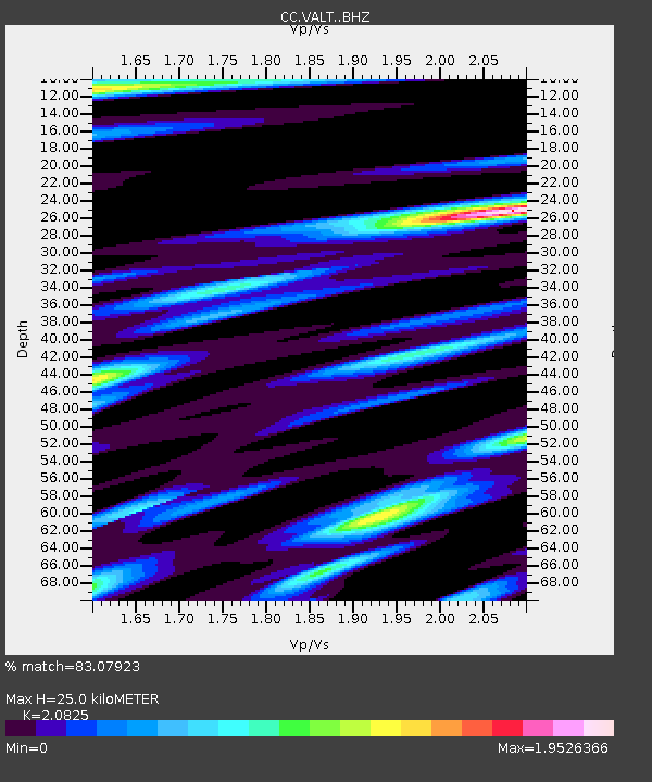
| Estimated Moho Depth: |
25.0 km |
| Estimated Crust Vp/Vs: |
2.08 |
| Assumed Crust Vp: |
6.566 km/s |
| Estimated Crust Vs: |
3.153 km/s |
| Estimated Crust Poisson's Ratio: |
0.35 |
|
| Radial Match: |
83.07923 % |
| Radial Bump: |
400 |
| Transverse Match: |
74.19326 % |
| Transverse Bump: |
400 |
| SOD ConfigId: |
13570011 |
| Insert Time: |
2019-04-28 23:56:26.015 +0000 |
| GWidth: |
2.5 |
| Max Bumps: |
400 |
| Tol: |
0.001 |
|

Signal To Noise
| Channel | StoN | STA | LTA |
| CC:VALT: :BHZ:20171018T12:12:43.700015Z | 5.3899593 | 1.6723563E-6 | 3.1027253E-7 |
| CC:VALT: :BHN:20171018T12:12:43.700015Z | 0.8150009 | 5.501639E-7 | 6.7504703E-7 |
| CC:VALT: :BHE:20171018T12:12:43.700015Z | 1.0139991 | 5.218621E-7 | 5.146573E-7 |
| Arrivals |
| Ps | 4.2 SECOND |
| PpPs | 11 SECOND |
| PsPs/PpSs | 16 SECOND |


