You are here: Home > Network List > CI - Caltech Regional Seismic Network Stations List
> Station SWS Sam W. Stewart, Westmorland, CA, USA > Earthquake Result Viewer
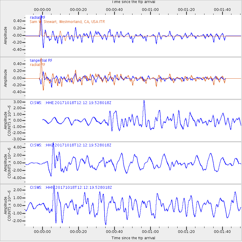
SWS Sam W. Stewart, Westmorland, CA, USA - Earthquake Result Viewer
*The percent match for this event was below the threshold and hence no stack was calculated.
| Earthquake location: |
Tonga Islands |
| Earthquake latitude/longitude: |
-20.6/-173.9 |
| Earthquake time(UTC): |
2017/10/18 (291) 12:00:59 GMT |
| Earthquake Depth: |
10 km |
| Earthquake Magnitude: |
6.0 Mww |
| Earthquake Catalog/Contributor: |
NEIC PDE/us |
|
| Network: |
CI Caltech Regional Seismic Network |
| Station: |
SWS Sam W. Stewart, Westmorland, CA, USA |
| Lat/Lon: |
32.94 N/115.80 W |
| Elevation: |
140 m |
|
| Distance: |
76.9 deg |
| Az: |
47.141 deg |
| Baz: |
234.753 deg |
| Ray Param: |
$rayparam |
*The percent match for this event was below the threshold and hence was not used in the summary stack. |
|
| Radial Match: |
74.568214 % |
| Radial Bump: |
400 |
| Transverse Match: |
75.81097 % |
| Transverse Bump: |
400 |
| SOD ConfigId: |
13570011 |
| Insert Time: |
2019-04-28 23:57:00.261 +0000 |
| GWidth: |
2.5 |
| Max Bumps: |
400 |
| Tol: |
0.001 |
|
Signal To Noise
| Channel | StoN | STA | LTA |
| CI:SWS: :HHZ:20171018T12:12:19.528018Z | 6.5916305 | 1.3558271E-6 | 2.0568918E-7 |
| CI:SWS: :HHN:20171018T12:12:19.528018Z | 1.6104189 | 4.437821E-7 | 2.7556936E-7 |
| CI:SWS: :HHE:20171018T12:12:19.528018Z | 0.69184166 | 2.2931115E-7 | 3.3145034E-7 |
| Arrivals |
| Ps | |
| PpPs | |
| PsPs/PpSs | |


