You are here: Home > Network List > CN - Canadian National Seismograph Network Stations List
> Station INK INUVIK, NT > Earthquake Result Viewer
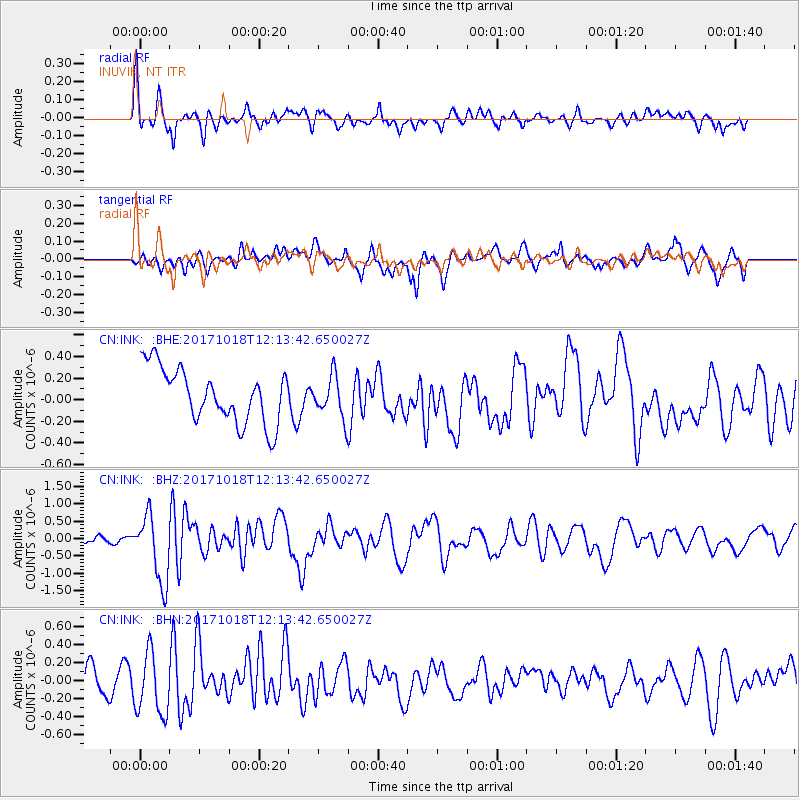
INK INUVIK, NT - Earthquake Result Viewer
*The percent match for this event was below the threshold and hence no stack was calculated.
| Earthquake location: |
Tonga Islands |
| Earthquake latitude/longitude: |
-20.6/-173.9 |
| Earthquake time(UTC): |
2017/10/18 (291) 12:00:59 GMT |
| Earthquake Depth: |
10 km |
| Earthquake Magnitude: |
6.0 Mww |
| Earthquake Catalog/Contributor: |
NEIC PDE/us |
|
| Network: |
CN Canadian National Seismograph Network |
| Station: |
INK INUVIK, NT |
| Lat/Lon: |
68.31 N/133.53 W |
| Elevation: |
44 m |
|
| Distance: |
93.4 deg |
| Az: |
13.96 deg |
| Baz: |
217.436 deg |
| Ray Param: |
$rayparam |
*The percent match for this event was below the threshold and hence was not used in the summary stack. |
|
| Radial Match: |
69.66798 % |
| Radial Bump: |
400 |
| Transverse Match: |
51.878647 % |
| Transverse Bump: |
400 |
| SOD ConfigId: |
13570011 |
| Insert Time: |
2019-04-28 23:57:16.147 +0000 |
| GWidth: |
2.5 |
| Max Bumps: |
400 |
| Tol: |
0.001 |
|
Signal To Noise
| Channel | StoN | STA | LTA |
| CN:INK: :BHZ:20171018T12:13:42.650027Z | 5.8469024 | 9.739183E-7 | 1.6656998E-7 |
| CN:INK: :BHN:20171018T12:13:42.650027Z | 1.8279084 | 3.4677183E-7 | 1.8970964E-7 |
| CN:INK: :BHE:20171018T12:13:42.650027Z | 0.97149235 | 2.3425503E-7 | 2.4112904E-7 |
| Arrivals |
| Ps | |
| PpPs | |
| PsPs/PpSs | |


