You are here: Home > Network List > NN - Western Great Basin/Eastern Sierra Nevada Stations List
> Station OMMB Old Mammoth Mine, surface, wgs-84 > Earthquake Result Viewer
OMMB Old Mammoth Mine, surface, wgs-84 - Earthquake Result Viewer
| Earthquake location: |
Tonga Islands |
| Earthquake latitude/longitude: |
-20.6/-173.9 |
| Earthquake time(UTC): |
2017/10/18 (291) 12:00:59 GMT |
| Earthquake Depth: |
10 km |
| Earthquake Magnitude: |
6.0 Mww |
| Earthquake Catalog/Contributor: |
NEIC PDE/us |
|
| Network: |
NN Western Great Basin/Eastern Sierra Nevada |
| Station: |
OMMB Old Mammoth Mine, surface, wgs-84 |
| Lat/Lon: |
37.61 N/119.00 W |
| Elevation: |
2768 m |
|
| Distance: |
77.6 deg |
| Az: |
41.703 deg |
| Baz: |
231.705 deg |
| Ray Param: |
0.05023449 |
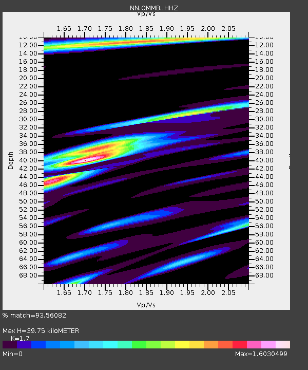
| Estimated Moho Depth: |
39.75 km |
| Estimated Crust Vp/Vs: |
1.70 |
| Assumed Crust Vp: |
6.291 km/s |
| Estimated Crust Vs: |
3.701 km/s |
| Estimated Crust Poisson's Ratio: |
0.24 |
|
| Radial Match: |
93.56082 % |
| Radial Bump: |
400 |
| Transverse Match: |
75.55367 % |
| Transverse Bump: |
400 |
| SOD ConfigId: |
13570011 |
| Insert Time: |
2019-04-28 23:58:55.775 +0000 |
| GWidth: |
2.5 |
| Max Bumps: |
400 |
| Tol: |
0.001 |
|

Signal To Noise
| Channel | StoN | STA | LTA |
| NN:OMMB: :HHZ:20171018T12:12:23.42499Z | 4.0123043 | 9.16151E-7 | 2.283354E-7 |
| NN:OMMB: :HHN:20171018T12:12:23.42499Z | 2.1629288 | 3.5895945E-7 | 1.659599E-7 |
| NN:OMMB: :HHE:20171018T12:12:23.42499Z | 2.5008938 | 4.259895E-7 | 1.7033491E-7 |
| Arrivals |
| Ps | 4.6 SECOND |
| PpPs | 17 SECOND |
| PsPs/PpSs | 21 SECOND |


