You are here: Home > Network List > S - Seismographs in Schools Projects Stations List
> Station AUKAL John Paul College, Kalgoorlie, WA > Earthquake Result Viewer
AUKAL John Paul College, Kalgoorlie, WA - Earthquake Result Viewer
| Earthquake location: |
Tonga Islands |
| Earthquake latitude/longitude: |
-20.6/-173.9 |
| Earthquake time(UTC): |
2017/10/18 (291) 12:00:59 GMT |
| Earthquake Depth: |
10 km |
| Earthquake Magnitude: |
6.0 Mww |
| Earthquake Catalog/Contributor: |
NEIC PDE/us |
|
| Network: |
S Seismographs in Schools Projects |
| Station: |
AUKAL John Paul College, Kalgoorlie, WA |
| Lat/Lon: |
30.76 S/121.48 E |
| Elevation: |
373 m |
|
| Distance: |
58.4 deg |
| Az: |
245.906 deg |
| Baz: |
96.519 deg |
| Ray Param: |
0.06285133 |
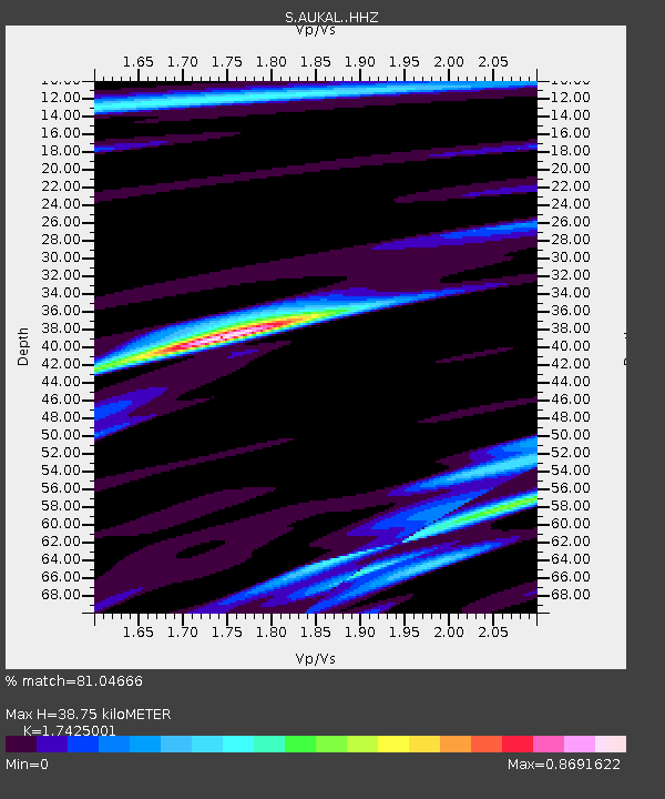
| Estimated Moho Depth: |
38.75 km |
| Estimated Crust Vp/Vs: |
1.74 |
| Assumed Crust Vp: |
6.459 km/s |
| Estimated Crust Vs: |
3.707 km/s |
| Estimated Crust Poisson's Ratio: |
0.25 |
|
| Radial Match: |
81.04666 % |
| Radial Bump: |
400 |
| Transverse Match: |
51.22894 % |
| Transverse Bump: |
400 |
| SOD ConfigId: |
13570011 |
| Insert Time: |
2019-04-29 00:00:11.696 +0000 |
| GWidth: |
2.5 |
| Max Bumps: |
400 |
| Tol: |
0.001 |
|

Signal To Noise
| Channel | StoN | STA | LTA |
| S:AUKAL: :HHZ:20171018T12:10:24.33002Z | 8.425424 | 3.5058479E-6 | 4.161035E-7 |
| S:AUKAL: :HHN:20171018T12:10:24.33002Z | 1.2811326 | 6.351031E-7 | 4.9573566E-7 |
| S:AUKAL: :HHE:20171018T12:10:24.33002Z | 3.6537848 | 2.173986E-6 | 5.949957E-7 |
| Arrivals |
| Ps | 4.7 SECOND |
| PpPs | 16 SECOND |
| PsPs/PpSs | 20 SECOND |


