You are here: Home > Network List > TA - USArray Transportable Network (new EarthScope stations) Stations List
> Station H19K Roundabout Mountain, AK, USA > Earthquake Result Viewer
H19K Roundabout Mountain, AK, USA - Earthquake Result Viewer
| Earthquake location: |
Tonga Islands |
| Earthquake latitude/longitude: |
-20.6/-173.9 |
| Earthquake time(UTC): |
2017/10/18 (291) 12:00:59 GMT |
| Earthquake Depth: |
10 km |
| Earthquake Magnitude: |
6.0 Mww |
| Earthquake Catalog/Contributor: |
NEIC PDE/us |
|
| Network: |
TA USArray Transportable Network (new EarthScope stations) |
| Station: |
H19K Roundabout Mountain, AK, USA |
| Lat/Lon: |
65.53 N/156.45 W |
| Elevation: |
107 m |
|
| Distance: |
86.9 deg |
| Az: |
7.185 deg |
| Baz: |
196.337 deg |
| Ray Param: |
0.043725986 |
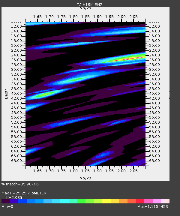
| Estimated Moho Depth: |
25.25 km |
| Estimated Crust Vp/Vs: |
2.04 |
| Assumed Crust Vp: |
6.182 km/s |
| Estimated Crust Vs: |
3.038 km/s |
| Estimated Crust Poisson's Ratio: |
0.34 |
|
| Radial Match: |
85.98796 % |
| Radial Bump: |
371 |
| Transverse Match: |
66.69315 % |
| Transverse Bump: |
350 |
| SOD ConfigId: |
13570011 |
| Insert Time: |
2019-04-29 00:01:36.515 +0000 |
| GWidth: |
2.5 |
| Max Bumps: |
400 |
| Tol: |
0.001 |
|

Signal To Noise
| Channel | StoN | STA | LTA |
| TA:H19K: :BHZ:20171018T12:13:12.275027Z | 8.418379 | 2.182307E-6 | 2.5923126E-7 |
| TA:H19K: :BHN:20171018T12:13:12.275027Z | 4.5602756 | 8.371044E-7 | 1.8356442E-7 |
| TA:H19K: :BHE:20171018T12:13:12.275027Z | 0.9301918 | 3.1051073E-7 | 3.3381363E-7 |
| Arrivals |
| Ps | 4.3 SECOND |
| PpPs | 12 SECOND |
| PsPs/PpSs | 16 SECOND |


