You are here: Home > Network List > TA - USArray Transportable Network (new EarthScope stations) Stations List
> Station H22K Ishtalitna Creek, AK, USA > Earthquake Result Viewer
H22K Ishtalitna Creek, AK, USA - Earthquake Result Viewer
| Earthquake location: |
Tonga Islands |
| Earthquake latitude/longitude: |
-20.6/-173.9 |
| Earthquake time(UTC): |
2017/10/18 (291) 12:00:59 GMT |
| Earthquake Depth: |
10 km |
| Earthquake Magnitude: |
6.0 Mww |
| Earthquake Catalog/Contributor: |
NEIC PDE/us |
|
| Network: |
TA USArray Transportable Network (new EarthScope stations) |
| Station: |
H22K Ishtalitna Creek, AK, USA |
| Lat/Lon: |
65.89 N/151.38 W |
| Elevation: |
561 m |
|
| Distance: |
87.9 deg |
| Az: |
9.056 deg |
| Baz: |
201.04 deg |
| Ray Param: |
0.042983092 |
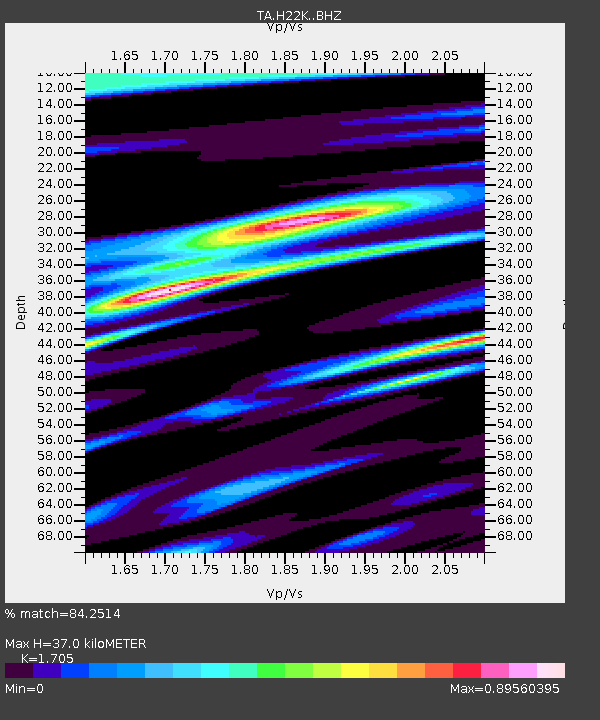
| Estimated Moho Depth: |
37.0 km |
| Estimated Crust Vp/Vs: |
1.71 |
| Assumed Crust Vp: |
6.566 km/s |
| Estimated Crust Vs: |
3.851 km/s |
| Estimated Crust Poisson's Ratio: |
0.24 |
|
| Radial Match: |
84.2514 % |
| Radial Bump: |
394 |
| Transverse Match: |
49.13505 % |
| Transverse Bump: |
381 |
| SOD ConfigId: |
13570011 |
| Insert Time: |
2019-04-29 00:01:39.878 +0000 |
| GWidth: |
2.5 |
| Max Bumps: |
400 |
| Tol: |
0.001 |
|

Signal To Noise
| Channel | StoN | STA | LTA |
| TA:H22K: :BHZ:20171018T12:13:17.17499Z | 8.16685 | 1.6689006E-6 | 2.0435058E-7 |
| TA:H22K: :BHN:20171018T12:13:17.17499Z | 3.8980641 | 7.493011E-7 | 1.922239E-7 |
| TA:H22K: :BHE:20171018T12:13:17.17499Z | 0.585544 | 1.7575256E-7 | 3.0015264E-7 |
| Arrivals |
| Ps | 4.1 SECOND |
| PpPs | 15 SECOND |
| PsPs/PpSs | 19 SECOND |


