You are here: Home > Network List > TA - USArray Transportable Network (new EarthScope stations) Stations List
> Station M31M Drury Creek, Yukon, CA > Earthquake Result Viewer
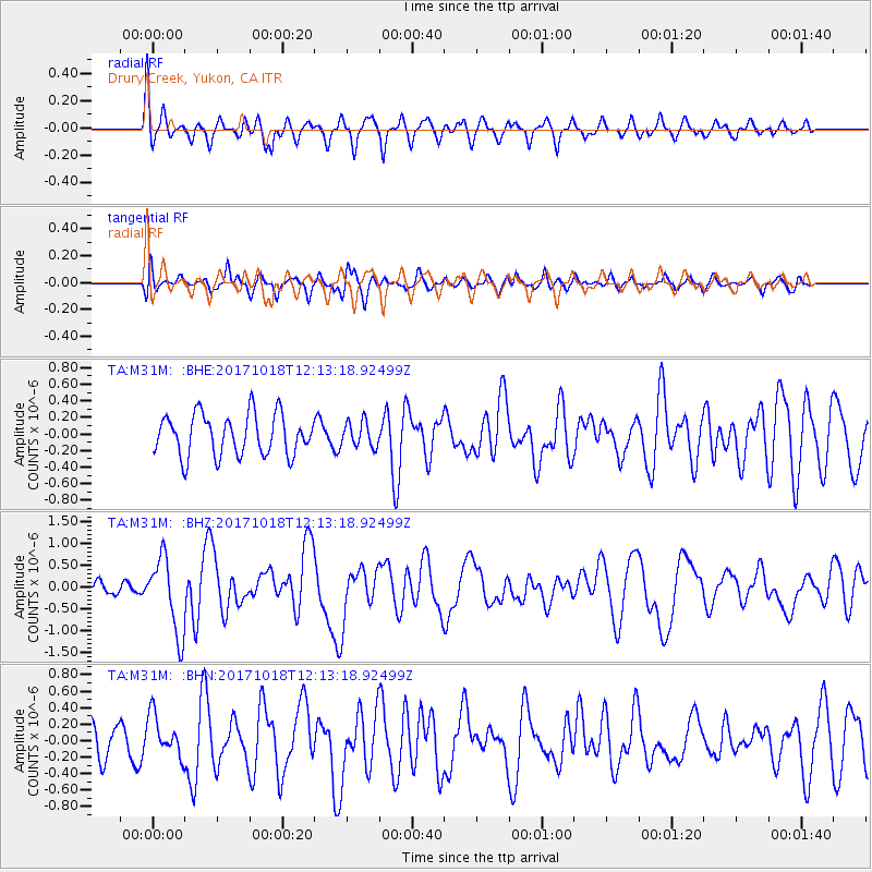
M31M Drury Creek, Yukon, CA - Earthquake Result Viewer
*The percent match for this event was below the threshold and hence no stack was calculated.
| Earthquake location: |
Tonga Islands |
| Earthquake latitude/longitude: |
-20.6/-173.9 |
| Earthquake time(UTC): |
2017/10/18 (291) 12:00:59 GMT |
| Earthquake Depth: |
10 km |
| Earthquake Magnitude: |
6.0 Mww |
| Earthquake Catalog/Contributor: |
NEIC PDE/us |
|
| Network: |
TA USArray Transportable Network (new EarthScope stations) |
| Station: |
M31M Drury Creek, Yukon, CA |
| Lat/Lon: |
62.20 N/134.39 W |
| Elevation: |
639 m |
|
| Distance: |
88.3 deg |
| Az: |
17.359 deg |
| Baz: |
216.6 deg |
| Ray Param: |
$rayparam |
*The percent match for this event was below the threshold and hence was not used in the summary stack. |
|
| Radial Match: |
59.98454 % |
| Radial Bump: |
400 |
| Transverse Match: |
50.260254 % |
| Transverse Bump: |
400 |
| SOD ConfigId: |
13570011 |
| Insert Time: |
2019-04-29 00:02:23.129 +0000 |
| GWidth: |
2.5 |
| Max Bumps: |
400 |
| Tol: |
0.001 |
|
Signal To Noise
| Channel | StoN | STA | LTA |
| TA:M31M: :BHZ:20171018T12:13:18.92499Z | 5.9628744 | 8.748835E-7 | 1.4672177E-7 |
| TA:M31M: :BHN:20171018T12:13:18.92499Z | 0.99755925 | 2.508881E-7 | 2.5150194E-7 |
| TA:M31M: :BHE:20171018T12:13:18.92499Z | 0.63561165 | 1.5840035E-7 | 2.4920934E-7 |
| Arrivals |
| Ps | |
| PpPs | |
| PsPs/PpSs | |


