You are here: Home > Network List > TA - USArray Transportable Network (new EarthScope stations) Stations List
> Station O18K Koktuh Hills, AK, USA > Earthquake Result Viewer
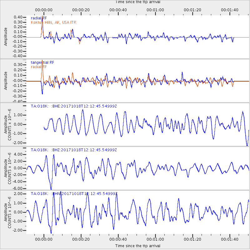
O18K Koktuh Hills, AK, USA - Earthquake Result Viewer
*The percent match for this event was below the threshold and hence no stack was calculated.
| Earthquake location: |
Tonga Islands |
| Earthquake latitude/longitude: |
-20.6/-173.9 |
| Earthquake time(UTC): |
2017/10/18 (291) 12:00:59 GMT |
| Earthquake Depth: |
10 km |
| Earthquake Magnitude: |
6.0 Mww |
| Earthquake Catalog/Contributor: |
NEIC PDE/us |
|
| Network: |
TA USArray Transportable Network (new EarthScope stations) |
| Station: |
O18K Koktuh Hills, AK, USA |
| Lat/Lon: |
59.85 N/155.21 W |
| Elevation: |
544 m |
|
| Distance: |
81.6 deg |
| Az: |
9.408 deg |
| Baz: |
197.663 deg |
| Ray Param: |
$rayparam |
*The percent match for this event was below the threshold and hence was not used in the summary stack. |
|
| Radial Match: |
73.05765 % |
| Radial Bump: |
400 |
| Transverse Match: |
64.671844 % |
| Transverse Bump: |
394 |
| SOD ConfigId: |
13570011 |
| Insert Time: |
2019-04-29 00:02:35.600 +0000 |
| GWidth: |
2.5 |
| Max Bumps: |
400 |
| Tol: |
0.001 |
|
Signal To Noise
| Channel | StoN | STA | LTA |
| TA:O18K: :BHZ:20171018T12:12:45.54999Z | 5.177195 | 3.0853475E-6 | 5.9594964E-7 |
| TA:O18K: :BHN:20171018T12:12:45.54999Z | 2.6513126 | 1.1790619E-6 | 4.4470872E-7 |
| TA:O18K: :BHE:20171018T12:12:45.54999Z | 0.94892055 | 6.697758E-7 | 7.0582917E-7 |
| Arrivals |
| Ps | |
| PpPs | |
| PsPs/PpSs | |


