You are here: Home > Network List > TA - USArray Transportable Network (new EarthScope stations) Stations List
> Station V35K Ketchikan, AK, USA > Earthquake Result Viewer
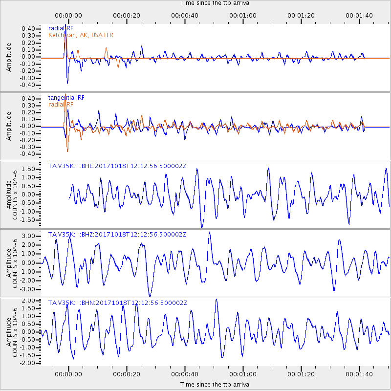
V35K Ketchikan, AK, USA - Earthquake Result Viewer
*The percent match for this event was below the threshold and hence no stack was calculated.
| Earthquake location: |
Tonga Islands |
| Earthquake latitude/longitude: |
-20.6/-173.9 |
| Earthquake time(UTC): |
2017/10/18 (291) 12:00:59 GMT |
| Earthquake Depth: |
10 km |
| Earthquake Magnitude: |
6.0 Mww |
| Earthquake Catalog/Contributor: |
NEIC PDE/us |
|
| Network: |
TA USArray Transportable Network (new EarthScope stations) |
| Station: |
V35K Ketchikan, AK, USA |
| Lat/Lon: |
55.33 N/131.62 W |
| Elevation: |
64 m |
|
| Distance: |
83.7 deg |
| Az: |
22.753 deg |
| Baz: |
219.35 deg |
| Ray Param: |
$rayparam |
*The percent match for this event was below the threshold and hence was not used in the summary stack. |
|
| Radial Match: |
65.23072 % |
| Radial Bump: |
400 |
| Transverse Match: |
60.925636 % |
| Transverse Bump: |
400 |
| SOD ConfigId: |
13570011 |
| Insert Time: |
2019-04-29 00:02:59.876 +0000 |
| GWidth: |
2.5 |
| Max Bumps: |
400 |
| Tol: |
0.001 |
|
Signal To Noise
| Channel | StoN | STA | LTA |
| TA:V35K: :BHZ:20171018T12:12:56.500002Z | 2.5953214 | 1.700057E-6 | 6.550468E-7 |
| TA:V35K: :BHN:20171018T12:12:56.500002Z | 2.7747102 | 1.1491603E-6 | 4.1415507E-7 |
| TA:V35K: :BHE:20171018T12:12:56.500002Z | 1.5009291 | 6.46942E-7 | 4.3102764E-7 |
| Arrivals |
| Ps | |
| PpPs | |
| PsPs/PpSs | |


