You are here: Home > Network List > TD - TransAlta Monitoring Network Stations List
> Station TD009 Z > Earthquake Result Viewer
TD009 Z - Earthquake Result Viewer
| Earthquake location: |
Tonga Islands |
| Earthquake latitude/longitude: |
-20.6/-173.9 |
| Earthquake time(UTC): |
2017/10/18 (291) 12:00:59 GMT |
| Earthquake Depth: |
10 km |
| Earthquake Magnitude: |
6.0 Mww |
| Earthquake Catalog/Contributor: |
NEIC PDE/us |
|
| Network: |
TD TransAlta Monitoring Network |
| Station: |
TD009 Z |
| Lat/Lon: |
52.32 N/116.32 W |
| Elevation: |
1335 m |
|
| Distance: |
88.2 deg |
| Az: |
31.223 deg |
| Baz: |
232.295 deg |
| Ray Param: |
0.04279977 |
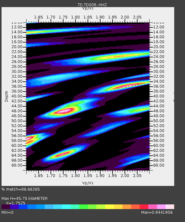
| Estimated Moho Depth: |
45.75 km |
| Estimated Crust Vp/Vs: |
1.75 |
| Assumed Crust Vp: |
6.142 km/s |
| Estimated Crust Vs: |
3.505 km/s |
| Estimated Crust Poisson's Ratio: |
0.26 |
|
| Radial Match: |
86.66265 % |
| Radial Bump: |
400 |
| Transverse Match: |
70.03788 % |
| Transverse Bump: |
400 |
| SOD ConfigId: |
13570011 |
| Insert Time: |
2019-04-29 00:03:09.117 +0000 |
| GWidth: |
2.5 |
| Max Bumps: |
400 |
| Tol: |
0.001 |
|

Signal To Noise
| Channel | StoN | STA | LTA |
| TD:TD009: :HHZ:20171018T12:13:18.200015Z | 4.294752 | 1.5596911E-6 | 3.631621E-7 |
| TD:TD009: :HH1:20171018T12:13:18.200015Z | 2.0232172 | 4.4356426E-7 | 2.1923711E-7 |
| TD:TD009: :HH2:20171018T12:13:18.200015Z | 1.3441368 | 2.316878E-7 | 1.7236921E-7 |
| Arrivals |
| Ps | 5.7 SECOND |
| PpPs | 20 SECOND |
| PsPs/PpSs | 26 SECOND |


