You are here: Home > Network List > TA - USArray Transportable Network (new EarthScope stations) Stations List
> Station I13A Wildhorse Creek, Mackay, ID, USA > Earthquake Result Viewer
I13A Wildhorse Creek, Mackay, ID, USA - Earthquake Result Viewer
| Earthquake location: |
Andreanof Islands, Aleutian Is. |
| Earthquake latitude/longitude: |
51.9/-177.5 |
| Earthquake time(UTC): |
2008/05/02 (123) 01:33:37 GMT |
| Earthquake Depth: |
14 km |
| Earthquake Magnitude: |
6.3 MB, 6.8 MS, 6.6 MW, 6.6 MW |
| Earthquake Catalog/Contributor: |
WHDF/NEIC |
|
| Network: |
TA USArray Transportable Network (new EarthScope stations) |
| Station: |
I13A Wildhorse Creek, Mackay, ID, USA |
| Lat/Lon: |
43.91 N/114.12 W |
| Elevation: |
2104 m |
|
| Distance: |
42.0 deg |
| Az: |
74.864 deg |
| Baz: |
304.08 deg |
| Ray Param: |
0.07340557 |
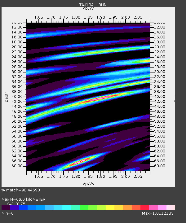
| Estimated Moho Depth: |
66.0 km |
| Estimated Crust Vp/Vs: |
1.82 |
| Assumed Crust Vp: |
6.291 km/s |
| Estimated Crust Vs: |
3.461 km/s |
| Estimated Crust Poisson's Ratio: |
0.28 |
|
| Radial Match: |
90.44693 % |
| Radial Bump: |
400 |
| Transverse Match: |
74.93724 % |
| Transverse Bump: |
400 |
| SOD ConfigId: |
2504 |
| Insert Time: |
2010-03-06 05:21:15.940 +0000 |
| GWidth: |
2.5 |
| Max Bumps: |
400 |
| Tol: |
0.001 |
|
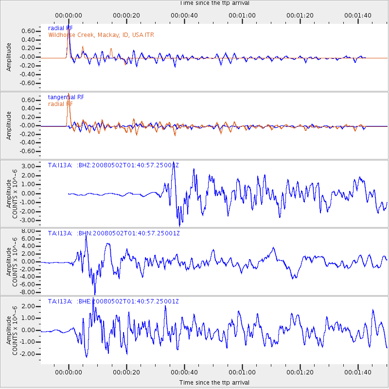
Signal To Noise
| Channel | StoN | STA | LTA |
| TA:I13A: :BHN:20080502T01:40:57.25001Z | 12.9275675 | 1.2480076E-6 | 9.653847E-8 |
| TA:I13A: :BHE:20080502T01:40:57.25001Z | 5.9846935 | 4.3224023E-7 | 7.222429E-8 |
| TA:I13A: :BHZ:20080502T01:40:57.25001Z | 6.192001 | 5.066917E-7 | 8.183005E-8 |
| Arrivals |
| Ps | 9.1 SECOND |
| PpPs | 28 SECOND |
| PsPs/PpSs | 37 SECOND |


