You are here: Home > Network List > UW - Pacific Northwest Regional Seismic Network Stations List
> Station BRAN Beach Ranch, Enterprise, OR, USA > Earthquake Result Viewer
BRAN Beach Ranch, Enterprise, OR, USA - Earthquake Result Viewer
| Earthquake location: |
Tonga Islands |
| Earthquake latitude/longitude: |
-20.6/-173.9 |
| Earthquake time(UTC): |
2017/10/18 (291) 12:00:59 GMT |
| Earthquake Depth: |
10 km |
| Earthquake Magnitude: |
6.0 Mww |
| Earthquake Catalog/Contributor: |
NEIC PDE/us |
|
| Network: |
UW Pacific Northwest Regional Seismic Network |
| Station: |
BRAN Beach Ranch, Enterprise, OR, USA |
| Lat/Lon: |
45.97 N/117.23 W |
| Elevation: |
1136 m |
|
| Distance: |
83.8 deg |
| Az: |
35.883 deg |
| Baz: |
231.94 deg |
| Ray Param: |
0.045945387 |
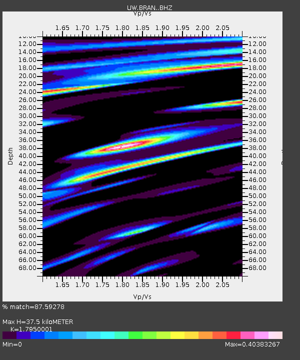
| Estimated Moho Depth: |
37.5 km |
| Estimated Crust Vp/Vs: |
1.80 |
| Assumed Crust Vp: |
6.571 km/s |
| Estimated Crust Vs: |
3.661 km/s |
| Estimated Crust Poisson's Ratio: |
0.27 |
|
| Radial Match: |
87.59278 % |
| Radial Bump: |
400 |
| Transverse Match: |
83.02058 % |
| Transverse Bump: |
400 |
| SOD ConfigId: |
13570011 |
| Insert Time: |
2019-04-29 00:03:41.822 +0000 |
| GWidth: |
2.5 |
| Max Bumps: |
400 |
| Tol: |
0.001 |
|

Signal To Noise
| Channel | StoN | STA | LTA |
| UW:BRAN: :BHZ:20171018T12:12:56.625002Z | 8.666715 | 1.7198213E-6 | 1.9843982E-7 |
| UW:BRAN: :BHN:20171018T12:12:56.625002Z | 2.077436 | 3.815953E-7 | 1.836857E-7 |
| UW:BRAN: :BHE:20171018T12:12:56.625002Z | 3.1034722 | 5.529119E-7 | 1.7815913E-7 |
| Arrivals |
| Ps | 4.7 SECOND |
| PpPs | 16 SECOND |
| PsPs/PpSs | 20 SECOND |


