You are here: Home > Network List > GS - US Geological Survey Networks Stations List
> Station OK035 E0210 Rd and N2420 Rd, Alva, Oklahoma, USA > Earthquake Result Viewer
OK035 E0210 Rd and N2420 Rd, Alva, Oklahoma, USA - Earthquake Result Viewer
| Earthquake location: |
Leeward Islands |
| Earthquake latitude/longitude: |
18.0/-60.7 |
| Earthquake time(UTC): |
2016/03/19 (079) 11:26:34 GMT |
| Earthquake Depth: |
32 km |
| Earthquake Magnitude: |
6.0 MWW, 5.9 MWB |
| Earthquake Catalog/Contributor: |
NEIC PDE/NEIC COMCAT |
|
| Network: |
GS US Geological Survey Networks |
| Station: |
OK035 E0210 Rd and N2420 Rd, Alva, Oklahoma, USA |
| Lat/Lon: |
36.71 N/98.71 W |
| Elevation: |
485 m |
|
| Distance: |
38.3 deg |
| Az: |
306.936 deg |
| Baz: |
108.806 deg |
| Ray Param: |
0.07560862 |
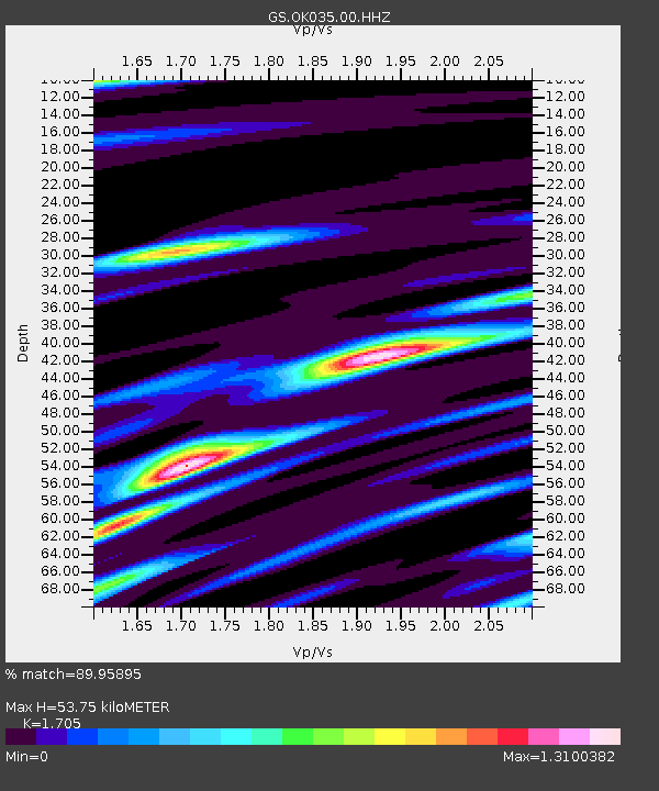
| Estimated Moho Depth: |
53.75 km |
| Estimated Crust Vp/Vs: |
1.71 |
| Assumed Crust Vp: |
6.426 km/s |
| Estimated Crust Vs: |
3.769 km/s |
| Estimated Crust Poisson's Ratio: |
0.24 |
|
| Radial Match: |
89.95895 % |
| Radial Bump: |
345 |
| Transverse Match: |
55.324654 % |
| Transverse Bump: |
400 |
| SOD ConfigId: |
1464191 |
| Insert Time: |
2016-04-02 12:02:33.224 +0000 |
| GWidth: |
2.5 |
| Max Bumps: |
400 |
| Tol: |
0.001 |
|

Signal To Noise
| Channel | StoN | STA | LTA |
| GS:OK035:00:HHZ:20160319T11:33:20.684001Z | 6.653914 | 1.2078618E-6 | 1.8152652E-7 |
| GS:OK035:00:HH1:20160319T11:33:20.684001Z | 1.6028286 | 4.3019585E-7 | 2.683979E-7 |
| GS:OK035:00:HH2:20160319T11:33:20.684001Z | 1.7027131 | 7.0910573E-7 | 4.1645637E-7 |
| Arrivals |
| Ps | 6.4 SECOND |
| PpPs | 21 SECOND |
| PsPs/PpSs | 27 SECOND |


