You are here: Home > Network List > TA - USArray Transportable Network (new EarthScope stations) Stations List
> Station I13A Wildhorse Creek, Mackay, ID, USA > Earthquake Result Viewer
I13A Wildhorse Creek, Mackay, ID, USA - Earthquake Result Viewer
| Earthquake location: |
Solomon Islands |
| Earthquake latitude/longitude: |
-10.5/161.3 |
| Earthquake time(UTC): |
2008/06/03 (155) 16:20:50 GMT |
| Earthquake Depth: |
84 km |
| Earthquake Magnitude: |
6.2 MB, 6.2 MW, 6.2 MW |
| Earthquake Catalog/Contributor: |
WHDF/NEIC |
|
| Network: |
TA USArray Transportable Network (new EarthScope stations) |
| Station: |
I13A Wildhorse Creek, Mackay, ID, USA |
| Lat/Lon: |
43.91 N/114.12 W |
| Elevation: |
2104 m |
|
| Distance: |
93.4 deg |
| Az: |
46.115 deg |
| Baz: |
258.747 deg |
| Ray Param: |
0.041234426 |
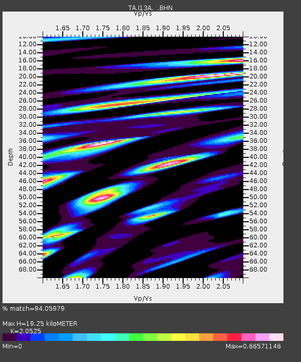
| Estimated Moho Depth: |
19.25 km |
| Estimated Crust Vp/Vs: |
2.05 |
| Assumed Crust Vp: |
6.291 km/s |
| Estimated Crust Vs: |
3.065 km/s |
| Estimated Crust Poisson's Ratio: |
0.34 |
|
| Radial Match: |
94.05979 % |
| Radial Bump: |
400 |
| Transverse Match: |
89.52794 % |
| Transverse Bump: |
400 |
| SOD ConfigId: |
2504 |
| Insert Time: |
2010-03-06 05:21:27.990 +0000 |
| GWidth: |
2.5 |
| Max Bumps: |
400 |
| Tol: |
0.001 |
|
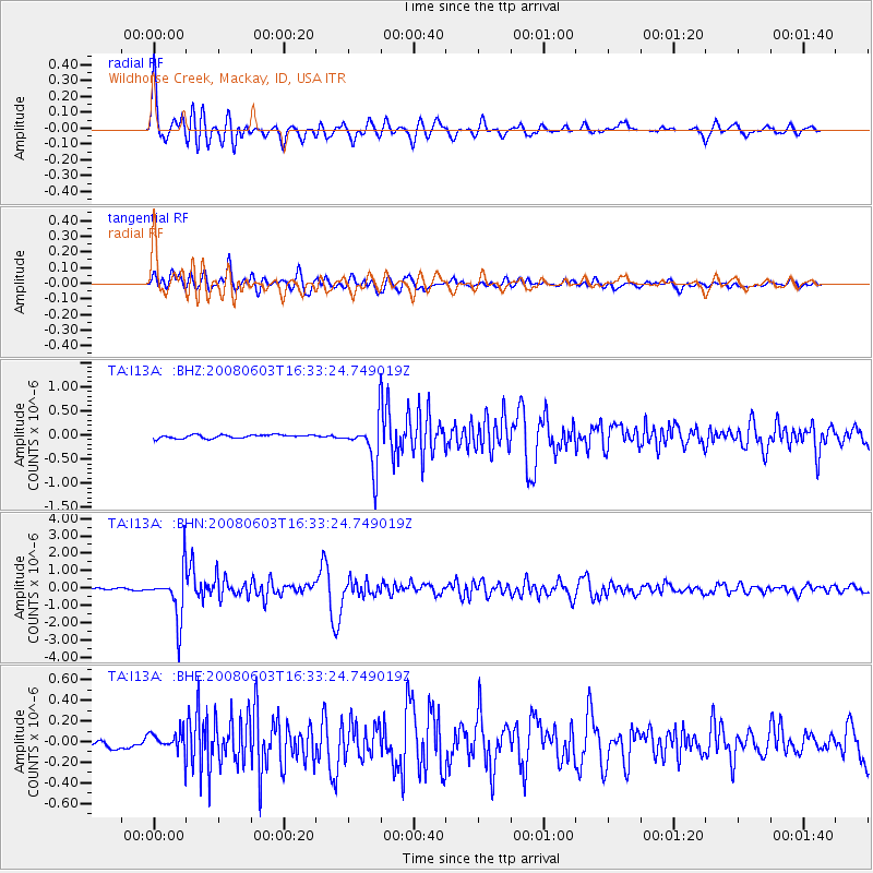
Signal To Noise
| Channel | StoN | STA | LTA |
| TA:I13A: :BHN:20080603T16:33:24.749019Z | 30.283157 | 1.4163423E-6 | 4.676997E-8 |
| TA:I13A: :BHE:20080603T16:33:24.749019Z | 2.175547 | 9.768363E-8 | 4.4900727E-8 |
| TA:I13A: :BHZ:20080603T16:33:24.749019Z | 13.51621 | 4.91356E-7 | 3.6353093E-8 |
| Arrivals |
| Ps | 3.3 SECOND |
| PpPs | 9.2 SECOND |
| PsPs/PpSs | 12 SECOND |


