You are here: Home > Network List > TA - USArray Transportable Network (new EarthScope stations) Stations List
> Station I13A Wildhorse Creek, Mackay, ID, USA > Earthquake Result Viewer
I13A Wildhorse Creek, Mackay, ID, USA - Earthquake Result Viewer
| Earthquake location: |
Off East Coast Of Honshu, Japan |
| Earthquake latitude/longitude: |
37.2/142.1 |
| Earthquake time(UTC): |
2008/07/21 (203) 11:30:29 GMT |
| Earthquake Depth: |
22 km |
| Earthquake Magnitude: |
5.7 MB, 5.6 MS, 6.0 MW, 5.9 MW |
| Earthquake Catalog/Contributor: |
WHDF/NEIC |
|
| Network: |
TA USArray Transportable Network (new EarthScope stations) |
| Station: |
I13A Wildhorse Creek, Mackay, ID, USA |
| Lat/Lon: |
43.91 N/114.12 W |
| Elevation: |
2104 m |
|
| Distance: |
73.9 deg |
| Az: |
46.931 deg |
| Baz: |
306.169 deg |
| Ray Param: |
0.052697696 |
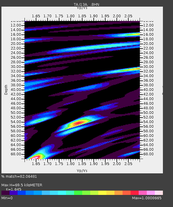
| Estimated Moho Depth: |
69.5 km |
| Estimated Crust Vp/Vs: |
1.64 |
| Assumed Crust Vp: |
6.291 km/s |
| Estimated Crust Vs: |
3.824 km/s |
| Estimated Crust Poisson's Ratio: |
0.21 |
|
| Radial Match: |
82.06481 % |
| Radial Bump: |
400 |
| Transverse Match: |
65.474976 % |
| Transverse Bump: |
400 |
| SOD ConfigId: |
2504 |
| Insert Time: |
2010-03-06 05:21:50.419 +0000 |
| GWidth: |
2.5 |
| Max Bumps: |
400 |
| Tol: |
0.001 |
|

Signal To Noise
| Channel | StoN | STA | LTA |
| TA:I13A: :BHN:20080721T11:41:31.05002Z | 4.781993 | 2.589123E-7 | 5.4143186E-8 |
| TA:I13A: :BHE:20080721T11:41:31.05002Z | 2.4508605 | 1.3030753E-7 | 5.3168076E-8 |
| TA:I13A: :BHZ:20080721T11:41:31.05002Z | 3.4168317 | 1.1066753E-7 | 3.2388932E-8 |
| Arrivals |
| Ps | 7.4 SECOND |
| PpPs | 28 SECOND |
| PsPs/PpSs | 36 SECOND |


