You are here: Home > Network List > GS - US Geological Survey Networks Stations List
> Station OK039 N2440 and E0440 Rds, Cleo Springs, OK, USA > Earthquake Result Viewer
OK039 N2440 and E0440 Rds, Cleo Springs, OK, USA - Earthquake Result Viewer
| Earthquake location: |
Leeward Islands |
| Earthquake latitude/longitude: |
18.0/-60.7 |
| Earthquake time(UTC): |
2016/03/19 (079) 11:26:34 GMT |
| Earthquake Depth: |
32 km |
| Earthquake Magnitude: |
6.0 MWW, 5.9 MWB |
| Earthquake Catalog/Contributor: |
NEIC PDE/NEIC COMCAT |
|
| Network: |
GS US Geological Survey Networks |
| Station: |
OK039 N2440 and E0440 Rds, Cleo Springs, OK, USA |
| Lat/Lon: |
36.38 N/98.65 W |
| Elevation: |
400 m |
|
| Distance: |
38.1 deg |
| Az: |
306.461 deg |
| Baz: |
108.467 deg |
| Ray Param: |
0.07569421 |
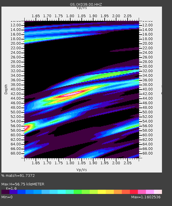
| Estimated Moho Depth: |
56.75 km |
| Estimated Crust Vp/Vs: |
1.60 |
| Assumed Crust Vp: |
6.426 km/s |
| Estimated Crust Vs: |
4.016 km/s |
| Estimated Crust Poisson's Ratio: |
0.18 |
|
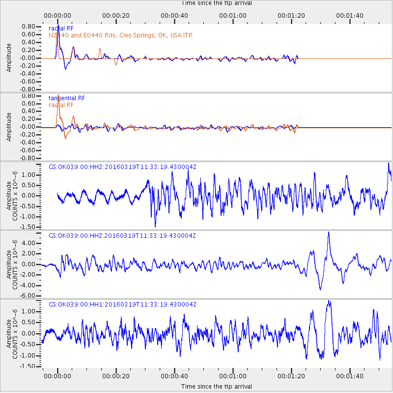
| Radial Match: |
91.7372 % |
| Radial Bump: |
312 |
| Transverse Match: |
64.85415 % |
| Transverse Bump: |
400 |
| SOD ConfigId: |
1464191 |
| Insert Time: |
2016-04-02 12:02:56.587 +0000 |
| GWidth: |
2.5 |
| Max Bumps: |
400 |
| Tol: |
0.001 |
|
Signal To Noise
| Channel | StoN | STA | LTA |
| GS:OK039:00:HHZ:20160319T11:33:19.430004Z | 6.3925104 | 1.1850519E-6 | 1.8538131E-7 |
| GS:OK039:00:HH1:20160319T11:33:19.430004Z | 0.770863 | 1.770355E-7 | 2.2965885E-7 |
| GS:OK039:00:HH2:20160319T11:33:19.430004Z | 3.238964 | 5.81122E-7 | 1.7941599E-7 |
| Arrivals |
| Ps | 5.7 SECOND |
| PpPs | 21 SECOND |
| PsPs/PpSs | 27 SECOND |


