You are here: Home > Network List > TA - USArray Transportable Network (new EarthScope stations) Stations List
> Station R31K City Hall, Gustavus, AK, USA > Earthquake Result Viewer
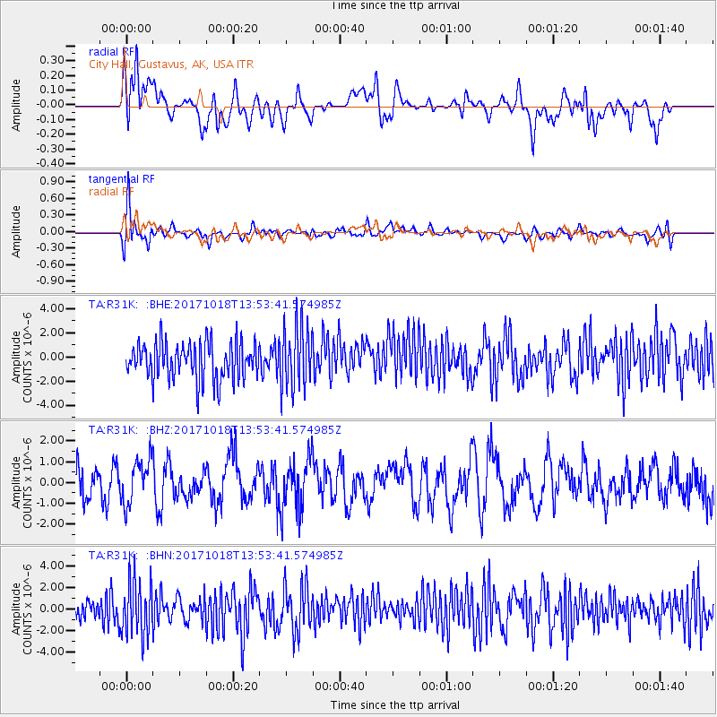
R31K City Hall, Gustavus, AK, USA - Earthquake Result Viewer
*The percent match for this event was below the threshold and hence no stack was calculated.
| Earthquake location: |
Minahassa Peninsula, Sulawesi |
| Earthquake latitude/longitude: |
-0.2/122.9 |
| Earthquake time(UTC): |
2017/10/18 (291) 13:40:55 GMT |
| Earthquake Depth: |
87 km |
| Earthquake Magnitude: |
5.3 Mww |
| Earthquake Catalog/Contributor: |
NEIC PDE/us |
|
| Network: |
TA USArray Transportable Network (new EarthScope stations) |
| Station: |
R31K City Hall, Gustavus, AK, USA |
| Lat/Lon: |
58.41 N/135.74 W |
| Elevation: |
15 m |
|
| Distance: |
96.1 deg |
| Az: |
31.266 deg |
| Baz: |
279.579 deg |
| Ray Param: |
$rayparam |
*The percent match for this event was below the threshold and hence was not used in the summary stack. |
|
| Radial Match: |
45.415703 % |
| Radial Bump: |
400 |
| Transverse Match: |
65.20392 % |
| Transverse Bump: |
400 |
| SOD ConfigId: |
13570011 |
| Insert Time: |
2019-04-29 00:07:43.020 +0000 |
| GWidth: |
2.5 |
| Max Bumps: |
400 |
| Tol: |
0.001 |
|
Signal To Noise
| Channel | StoN | STA | LTA |
| TA:R31K: :BHZ:20171018T13:53:41.574985Z | 1.0375032 | 1.0687871E-6 | 1.030153E-6 |
| TA:R31K: :BHN:20171018T13:53:41.574985Z | 2.0811462 | 2.6177631E-6 | 1.2578469E-6 |
| TA:R31K: :BHE:20171018T13:53:41.574985Z | 1.6990215 | 2.6053779E-6 | 1.533458E-6 |
| Arrivals |
| Ps | |
| PpPs | |
| PsPs/PpSs | |


