You are here: Home > Network List > AT - Alaska Tsunami Warning Seismic System Stations List
> Station OHAK Old Harbor, Alaska > Earthquake Result Viewer
OHAK Old Harbor, Alaska - Earthquake Result Viewer
| Earthquake location: |
Eastern New Guinea Reg., P.N.G. |
| Earthquake latitude/longitude: |
-5.6/147.2 |
| Earthquake time(UTC): |
2017/10/18 (291) 16:44:35 GMT |
| Earthquake Depth: |
193 km |
| Earthquake Magnitude: |
5.6 Mww |
| Earthquake Catalog/Contributor: |
NEIC PDE/us |
|
| Network: |
AT Alaska Tsunami Warning Seismic System |
| Station: |
OHAK Old Harbor, Alaska |
| Lat/Lon: |
57.22 N/153.29 W |
| Elevation: |
78 m |
|
| Distance: |
78.8 deg |
| Az: |
28.548 deg |
| Baz: |
240.983 deg |
| Ray Param: |
0.04889225 |
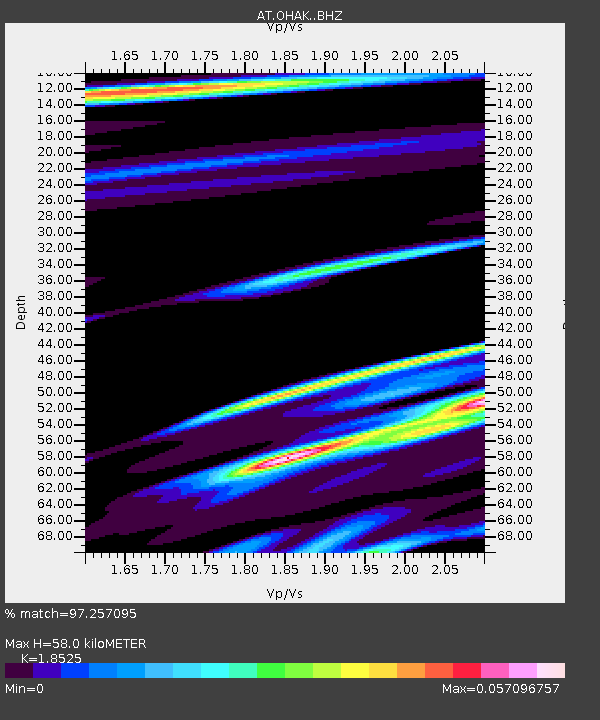
| Estimated Moho Depth: |
58.0 km |
| Estimated Crust Vp/Vs: |
1.85 |
| Assumed Crust Vp: |
6.134 km/s |
| Estimated Crust Vs: |
3.311 km/s |
| Estimated Crust Poisson's Ratio: |
0.29 |
|
| Radial Match: |
97.257095 % |
| Radial Bump: |
166 |
| Transverse Match: |
97.20806 % |
| Transverse Bump: |
182 |
| SOD ConfigId: |
13570011 |
| Insert Time: |
2019-04-29 00:08:35.756 +0000 |
| GWidth: |
2.5 |
| Max Bumps: |
400 |
| Tol: |
0.001 |
|

Signal To Noise
| Channel | StoN | STA | LTA |
| AT:OHAK: :BHZ:20171018T16:55:45.560005Z | 1.0076725 | 1.8805304E-7 | 1.8662118E-7 |
| AT:OHAK: :BHN:20171018T16:55:45.560005Z | 0.81538 | 9.7223264E-8 | 1.1923676E-7 |
| AT:OHAK: :BHE:20171018T16:55:45.560005Z | 1.1838621 | 3.9578723E-9 | 3.3431868E-9 |
| Arrivals |
| Ps | 8.3 SECOND |
| PpPs | 26 SECOND |
| PsPs/PpSs | 35 SECOND |


