You are here: Home > Network List > CI - Caltech Regional Seismic Network Stations List
> Station SMM Simmler, CA, USA > Earthquake Result Viewer
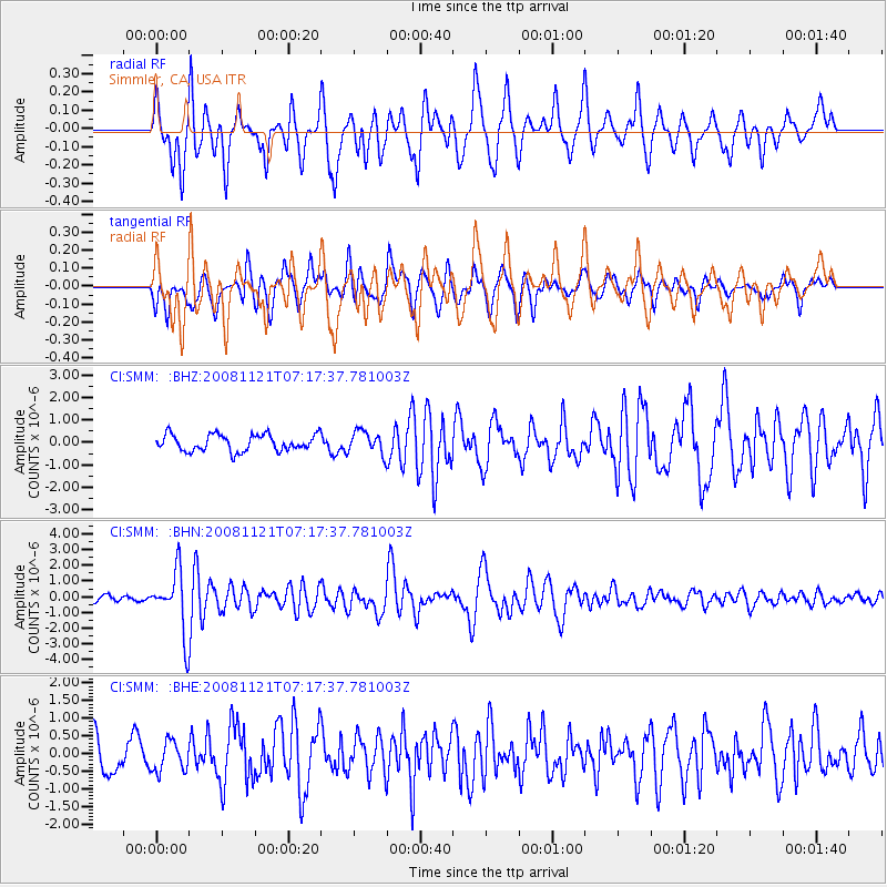
SMM Simmler, CA, USA - Earthquake Result Viewer
*The percent match for this event was below the threshold and hence no stack was calculated.
| Earthquake location: |
Solomon Islands |
| Earthquake latitude/longitude: |
-8.9/159.6 |
| Earthquake time(UTC): |
2008/11/21 (326) 07:05:34 GMT |
| Earthquake Depth: |
118 km |
| Earthquake Magnitude: |
6.0 MB, 6.1 MW, 6.0 MW |
| Earthquake Catalog/Contributor: |
WHDF/NEIC |
|
| Network: |
CI Caltech Regional Seismic Network |
| Station: |
SMM Simmler, CA, USA |
| Lat/Lon: |
35.31 N/120.00 W |
| Elevation: |
599 m |
|
| Distance: |
87.4 deg |
| Az: |
53.834 deg |
| Baz: |
257.238 deg |
| Ray Param: |
$rayparam |
*The percent match for this event was below the threshold and hence was not used in the summary stack. |
|
| Radial Match: |
77.736145 % |
| Radial Bump: |
400 |
| Transverse Match: |
61.41972 % |
| Transverse Bump: |
400 |
| SOD ConfigId: |
2658 |
| Insert Time: |
2010-02-26 01:32:29.636 +0000 |
| GWidth: |
2.5 |
| Max Bumps: |
400 |
| Tol: |
0.001 |
|
Signal To Noise
| Channel | StoN | STA | LTA |
| CI:SMM: :BHN:20081121T07:17:37.781003Z | 6.8090153 | 1.9486884E-6 | 2.861924E-7 |
| CI:SMM: :BHE:20081121T07:17:37.781003Z | 1.0131993 | 4.2853955E-7 | 4.2295682E-7 |
| CI:SMM: :BHZ:20081121T07:17:37.781003Z | 1.3918288 | 5.0692813E-7 | 3.6421733E-7 |
| Arrivals |
| Ps | |
| PpPs | |
| PsPs/PpSs | |


