You are here: Home > Network List > TA - USArray Transportable Network (new EarthScope stations) Stations List
> Station I13A Wildhorse Creek, Mackay, ID, USA > Earthquake Result Viewer
I13A Wildhorse Creek, Mackay, ID, USA - Earthquake Result Viewer
| Earthquake location: |
Vanuatu Islands |
| Earthquake latitude/longitude: |
-14.8/168.0 |
| Earthquake time(UTC): |
2008/11/07 (312) 07:19:35 GMT |
| Earthquake Depth: |
13 km |
| Earthquake Magnitude: |
6.0 MB, 6.3 MS, 6.4 MW, 6.4 MW |
| Earthquake Catalog/Contributor: |
WHDF/NEIC |
|
| Network: |
TA USArray Transportable Network (new EarthScope stations) |
| Station: |
I13A Wildhorse Creek, Mackay, ID, USA |
| Lat/Lon: |
43.91 N/114.12 W |
| Elevation: |
2104 m |
|
| Distance: |
91.6 deg |
| Az: |
44.975 deg |
| Baz: |
251.058 deg |
| Ray Param: |
0.04157747 |
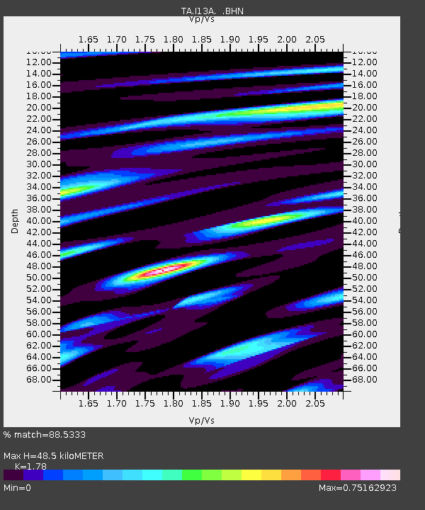
| Estimated Moho Depth: |
48.5 km |
| Estimated Crust Vp/Vs: |
1.78 |
| Assumed Crust Vp: |
6.291 km/s |
| Estimated Crust Vs: |
3.534 km/s |
| Estimated Crust Poisson's Ratio: |
0.27 |
|
| Radial Match: |
88.5333 % |
| Radial Bump: |
400 |
| Transverse Match: |
81.87174 % |
| Transverse Bump: |
400 |
| SOD ConfigId: |
2658 |
| Insert Time: |
2010-03-06 05:22:24.215 +0000 |
| GWidth: |
2.5 |
| Max Bumps: |
400 |
| Tol: |
0.001 |
|

Signal To Noise
| Channel | StoN | STA | LTA |
| TA:I13A: :BHN:20081107T07:32:10.824014Z | 4.5912046 | 3.4727358E-7 | 7.563889E-8 |
| TA:I13A: :BHE:20081107T07:32:10.824014Z | 0.5881928 | 4.6136137E-8 | 7.84371E-8 |
| TA:I13A: :BHZ:20081107T07:32:10.824014Z | 2.6991944 | 1.8928918E-7 | 7.0128024E-8 |
| Arrivals |
| Ps | 6.1 SECOND |
| PpPs | 21 SECOND |
| PsPs/PpSs | 27 SECOND |


