You are here: Home > Network List > TA - USArray Transportable Network (new EarthScope stations) Stations List
> Station F24K Squaw Lake, AK, USA > Earthquake Result Viewer
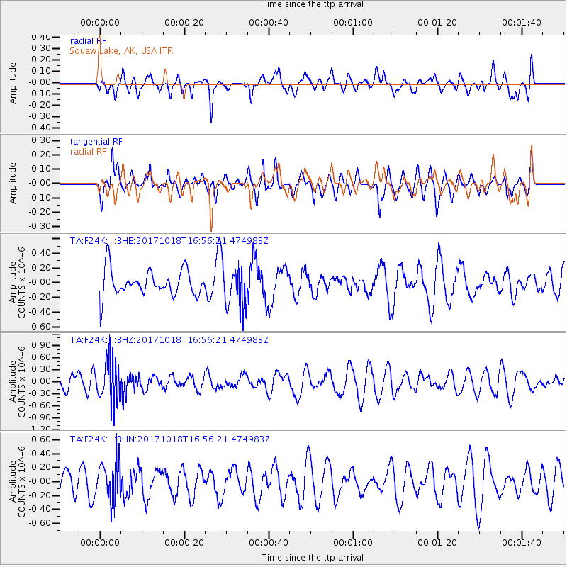
F24K Squaw Lake, AK, USA - Earthquake Result Viewer
*The percent match for this event was below the threshold and hence no stack was calculated.
| Earthquake location: |
Eastern New Guinea Reg., P.N.G. |
| Earthquake latitude/longitude: |
-5.6/147.2 |
| Earthquake time(UTC): |
2017/10/18 (291) 16:44:35 GMT |
| Earthquake Depth: |
193 km |
| Earthquake Magnitude: |
5.6 Mww |
| Earthquake Catalog/Contributor: |
NEIC PDE/us |
|
| Network: |
TA USArray Transportable Network (new EarthScope stations) |
| Station: |
F24K Squaw Lake, AK, USA |
| Lat/Lon: |
67.52 N/147.89 W |
| Elevation: |
736 m |
|
| Distance: |
85.8 deg |
| Az: |
20.444 deg |
| Baz: |
244.693 deg |
| Ray Param: |
$rayparam |
*The percent match for this event was below the threshold and hence was not used in the summary stack. |
|
| Radial Match: |
52.975624 % |
| Radial Bump: |
400 |
| Transverse Match: |
50.353363 % |
| Transverse Bump: |
335 |
| SOD ConfigId: |
13570011 |
| Insert Time: |
2019-04-29 00:10:37.001 +0000 |
| GWidth: |
2.5 |
| Max Bumps: |
400 |
| Tol: |
0.001 |
|
Signal To Noise
| Channel | StoN | STA | LTA |
| TA:F24K: :BHZ:20171018T16:56:21.474983Z | 1.9304854 | 5.085496E-7 | 2.6343096E-7 |
| TA:F24K: :BHN:20171018T16:56:21.474983Z | 1.4416279 | 2.7597932E-7 | 1.9143587E-7 |
| TA:F24K: :BHE:20171018T16:56:21.474983Z | 1.5439993 | 2.7625066E-7 | 1.789189E-7 |
| Arrivals |
| Ps | |
| PpPs | |
| PsPs/PpSs | |


