You are here: Home > Network List > UW - Pacific Northwest Regional Seismic Network Stations List
> Station LEBA Lebam, WA, USA > Earthquake Result Viewer
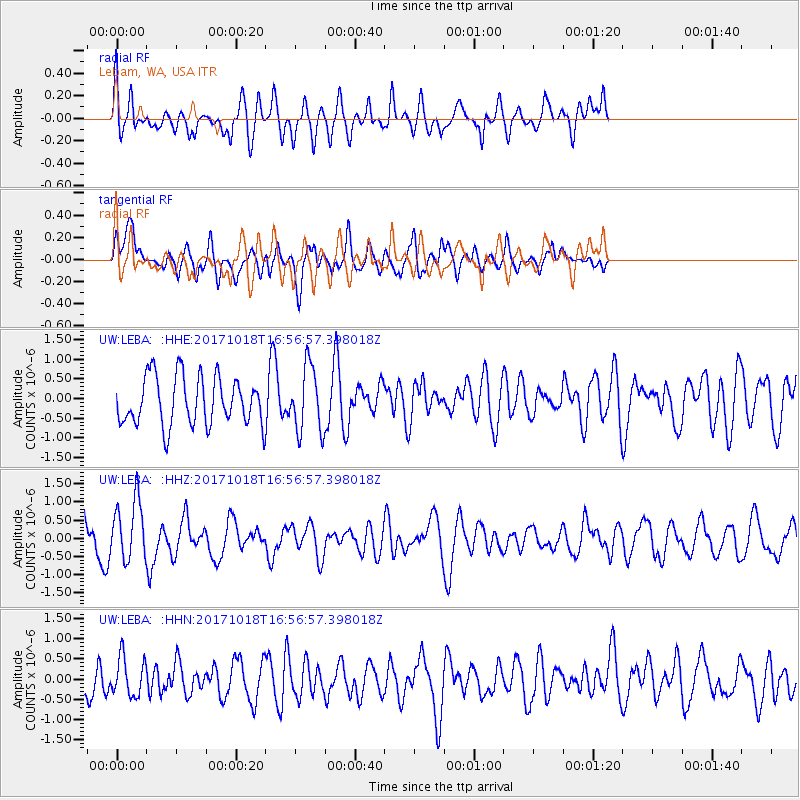
LEBA Lebam, WA, USA - Earthquake Result Viewer
*The percent match for this event was below the threshold and hence no stack was calculated.
| Earthquake location: |
Eastern New Guinea Reg., P.N.G. |
| Earthquake latitude/longitude: |
-5.6/147.2 |
| Earthquake time(UTC): |
2017/10/18 (291) 16:44:35 GMT |
| Earthquake Depth: |
193 km |
| Earthquake Magnitude: |
5.6 Mww |
| Earthquake Catalog/Contributor: |
NEIC PDE/us |
|
| Network: |
UW Pacific Northwest Regional Seismic Network |
| Station: |
LEBA Lebam, WA, USA |
| Lat/Lon: |
46.55 N/123.56 W |
| Elevation: |
73 m |
|
| Distance: |
93.5 deg |
| Az: |
43.743 deg |
| Baz: |
265.644 deg |
| Ray Param: |
$rayparam |
*The percent match for this event was below the threshold and hence was not used in the summary stack. |
|
| Radial Match: |
55.167343 % |
| Radial Bump: |
400 |
| Transverse Match: |
47.982605 % |
| Transverse Bump: |
400 |
| SOD ConfigId: |
13570011 |
| Insert Time: |
2019-04-29 00:11:23.672 +0000 |
| GWidth: |
2.5 |
| Max Bumps: |
400 |
| Tol: |
0.001 |
|
Signal To Noise
| Channel | StoN | STA | LTA |
| UW:LEBA: :HHZ:20171018T16:56:57.398018Z | 2.1150687 | 8.220668E-7 | 3.8867142E-7 |
| UW:LEBA: :HHN:20171018T16:56:57.398018Z | 0.82432956 | 4.766753E-7 | 5.782582E-7 |
| UW:LEBA: :HHE:20171018T16:56:57.398018Z | 1.3576581 | 8.294604E-7 | 6.109494E-7 |
| Arrivals |
| Ps | |
| PpPs | |
| PsPs/PpSs | |


