You are here: Home > Network List > AC - Albanian Seismological Network Stations List
> Station LSK LSK > Earthquake Result Viewer
LSK LSK - Earthquake Result Viewer
| Earthquake location: |
Southeast Of Ryukyu Islands |
| Earthquake latitude/longitude: |
28.3/131.2 |
| Earthquake time(UTC): |
2017/10/19 (292) 09:02:01 GMT |
| Earthquake Depth: |
10 km |
| Earthquake Magnitude: |
5.8 Mww |
| Earthquake Catalog/Contributor: |
NEIC PDE/us |
|
| Network: |
AC Albanian Seismological Network |
| Station: |
LSK LSK |
| Lat/Lon: |
40.15 N/20.60 E |
| Elevation: |
960 m |
|
| Distance: |
86.3 deg |
| Az: |
314.028 deg |
| Baz: |
55.793 deg |
| Ray Param: |
0.044181675 |
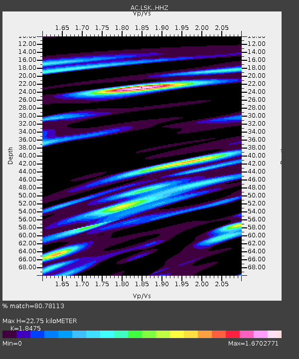
| Estimated Moho Depth: |
22.75 km |
| Estimated Crust Vp/Vs: |
1.85 |
| Assumed Crust Vp: |
6.291 km/s |
| Estimated Crust Vs: |
3.405 km/s |
| Estimated Crust Poisson's Ratio: |
0.29 |
|
| Radial Match: |
80.78113 % |
| Radial Bump: |
400 |
| Transverse Match: |
67.455246 % |
| Transverse Bump: |
400 |
| SOD ConfigId: |
13570011 |
| Insert Time: |
2019-04-29 00:11:59.564 +0000 |
| GWidth: |
2.5 |
| Max Bumps: |
400 |
| Tol: |
0.001 |
|

Signal To Noise
| Channel | StoN | STA | LTA |
| AC:LSK: :HHZ:20171019T09:14:12.113989Z | 10.918049 | 8.722873E-7 | 7.9894065E-8 |
| AC:LSK: :HHN:20171019T09:14:12.113989Z | 2.8454332 | 2.6945926E-7 | 9.4698855E-8 |
| AC:LSK: :HHE:20171019T09:14:12.113989Z | 2.4609118 | 2.3469377E-7 | 9.5368634E-8 |
| Arrivals |
| Ps | 3.1 SECOND |
| PpPs | 10 SECOND |
| PsPs/PpSs | 13 SECOND |


