You are here: Home > Network List > TA - USArray Transportable Network (new EarthScope stations) Stations List
> Station I13A Wildhorse Creek, Mackay, ID, USA > Earthquake Result Viewer
I13A Wildhorse Creek, Mackay, ID, USA - Earthquake Result Viewer
| Earthquake location: |
Arctic Ocean |
| Earthquake latitude/longitude: |
79.6/-116.1 |
| Earthquake time(UTC): |
2008/11/17 (322) 12:55:22 GMT |
| Earthquake Depth: |
7.0 km |
| Earthquake Magnitude: |
5.7 MW, 5.2 MS, 5.4 MB, 5.7 MW |
| Earthquake Catalog/Contributor: |
WHDF/NEIC |
|
| Network: |
TA USArray Transportable Network (new EarthScope stations) |
| Station: |
I13A Wildhorse Creek, Mackay, ID, USA |
| Lat/Lon: |
43.91 N/114.12 W |
| Elevation: |
2104 m |
|
| Distance: |
35.9 deg |
| Az: |
177.608 deg |
| Baz: |
359.401 deg |
| Ray Param: |
0.077000275 |
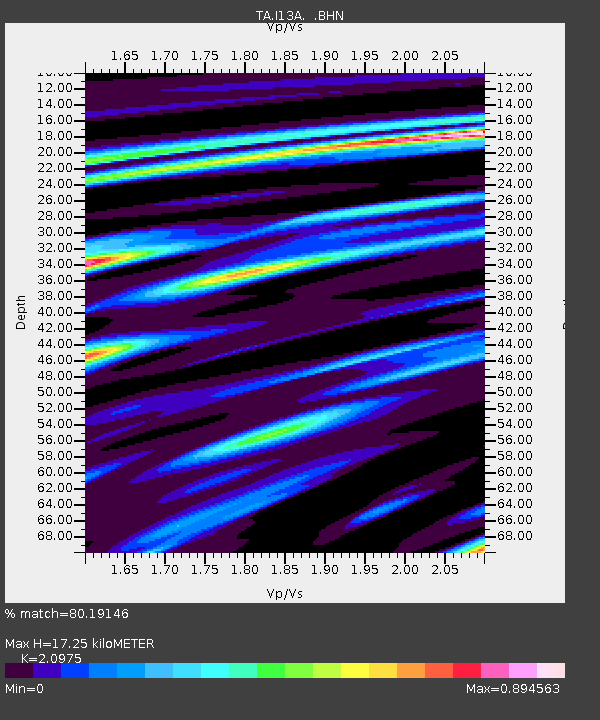
| Estimated Moho Depth: |
17.25 km |
| Estimated Crust Vp/Vs: |
2.10 |
| Assumed Crust Vp: |
6.291 km/s |
| Estimated Crust Vs: |
2.999 km/s |
| Estimated Crust Poisson's Ratio: |
0.35 |
|
| Radial Match: |
80.19146 % |
| Radial Bump: |
357 |
| Transverse Match: |
69.63659 % |
| Transverse Bump: |
400 |
| SOD ConfigId: |
2658 |
| Insert Time: |
2010-03-06 05:22:54.482 +0000 |
| GWidth: |
2.5 |
| Max Bumps: |
400 |
| Tol: |
0.001 |
|
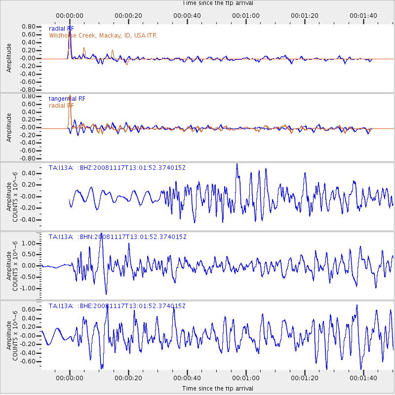
Signal To Noise
| Channel | StoN | STA | LTA |
| TA:I13A: :BHN:20081117T13:01:52.374015Z | 2.619775 | 2.9402864E-7 | 1.12234304E-7 |
| TA:I13A: :BHE:20081117T13:01:52.374015Z | 1.924616 | 1.5441684E-7 | 8.023254E-8 |
| TA:I13A: :BHZ:20081117T13:01:52.374015Z | 1.1294023 | 1.0044654E-7 | 8.893779E-8 |
| Arrivals |
| Ps | 3.2 SECOND |
| PpPs | 8.0 SECOND |
| PsPs/PpSs | 11 SECOND |


