You are here: Home > Network List > AK - Alaska Regional Network Stations List
> Station MDM Murphy Dome > Earthquake Result Viewer
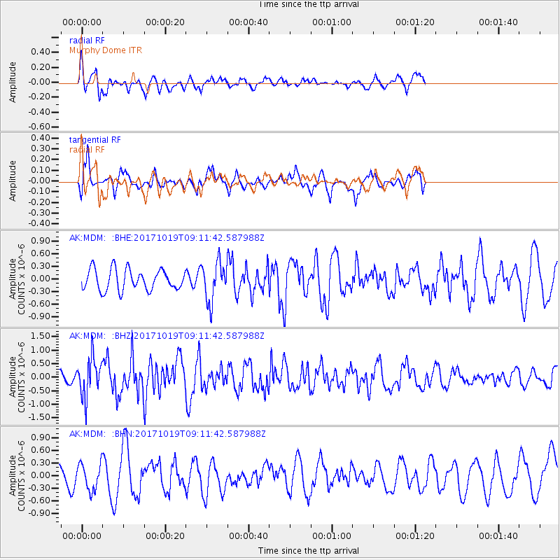
MDM Murphy Dome - Earthquake Result Viewer
*The percent match for this event was below the threshold and hence no stack was calculated.
| Earthquake location: |
Southeast Of Ryukyu Islands |
| Earthquake latitude/longitude: |
28.3/131.2 |
| Earthquake time(UTC): |
2017/10/19 (292) 09:02:01 GMT |
| Earthquake Depth: |
10 km |
| Earthquake Magnitude: |
5.8 Mww |
| Earthquake Catalog/Contributor: |
NEIC PDE/us |
|
| Network: |
AK Alaska Regional Network |
| Station: |
MDM Murphy Dome |
| Lat/Lon: |
64.96 N/148.23 W |
| Elevation: |
634 m |
|
| Distance: |
60.8 deg |
| Az: |
28.763 deg |
| Baz: |
274.611 deg |
| Ray Param: |
$rayparam |
*The percent match for this event was below the threshold and hence was not used in the summary stack. |
|
| Radial Match: |
54.20888 % |
| Radial Bump: |
369 |
| Transverse Match: |
57.290295 % |
| Transverse Bump: |
376 |
| SOD ConfigId: |
13570011 |
| Insert Time: |
2019-04-29 00:12:20.212 +0000 |
| GWidth: |
2.5 |
| Max Bumps: |
400 |
| Tol: |
0.001 |
|
Signal To Noise
| Channel | StoN | STA | LTA |
| AK:MDM: :BHZ:20171019T09:11:42.587988Z | 3.5571492 | 7.1935165E-7 | 2.0222701E-7 |
| AK:MDM: :BHN:20171019T09:11:42.587988Z | 1.1125386 | 3.2010755E-7 | 2.8772715E-7 |
| AK:MDM: :BHE:20171019T09:11:42.587988Z | 1.8826503 | 4.6124597E-7 | 2.4499823E-7 |
| Arrivals |
| Ps | |
| PpPs | |
| PsPs/PpSs | |


